Scrolling through a list of land listings and trying to visualize where each parcel sits is one of the most inefficient ways to buy land. Location shapes value more than almost any other factor, and a text-based list tells you nothing about what surrounds a parcel, what zoning it carries, or whether access roads even reach it. Searching land for sale by map flips that process entirely. Instead of reading about land, you see it.
This guide walks through how to run an effective land for sale map search, what filters actually matter, and how tools like Acres.com give buyers a complete picture of every parcel before they ever contact a seller.
Contents
Why Traditional Land Listings Fall Short for Buyers
How to Search Land for Sale by Map in 5 Steps
How Acres Makes Land for Sale Map Search More Effective
Key Takeaways: Search Land for Sale by Map the Right Way
Why Traditional Land Listings Fall Short for Buyers
Most online land listings were built for residential real estate buyers, not land buyers. The search filters default to beds, baths, and square footage. Location data is limited to a pin on a map with no context about what surrounds the parcel. For vacant land, that context is everything.
Land buyers need to know about zoning classifications, road frontage, flood exposure, utility access, and neighboring land uses. A 40-acre tract listed at $2,000 per acre may be priced fairly or may carry a flood designation that makes it unbuildable. FEMA estimates that roughly 8.7 million properties across the U.S. sit within a Special Flood Hazard Area, a figure that does not show up in most standard listing platforms.
An interactive land map search changes what buyers can evaluate before the first phone call. Layers for zoning, ownership, parcel boundaries, and environmental risk turn a visual map into a due diligence tool. The buyer who uses map-based search walks into every conversation with better information than the buyer who relied on a static listing page.
How to Search Land for Sale by Map in 5 Steps
Step 1: Start With a Map-First Search Tool, Not a Listing Aggregator
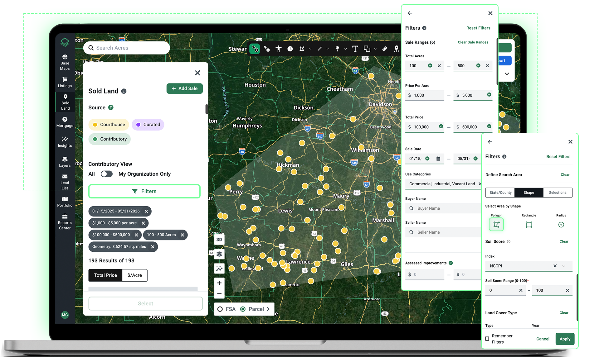
The starting point matters. A listing aggregator shows you properties with a map pinned to each one. A map-first land search tool shows you the land itself, with parcel boundaries, data layers, and filters built around how land buyers actually make decisions.
Open a map-based land search platform and zoom to your target geography. Parcel boundaries should be visible at the county or township level. Every parcel on the map should be clickable, returning ownership data, size, zoning classification, and sale history. If the platform only shows listed properties, you are looking at a subset of what is available, not the full market.
With Acres:
The Acres map displays parcel boundaries and data for over 150 million parcels nationwide. Click any parcel to pull ownership, acreage, zoning, and transaction history instantly, whether the parcel is listed for sale or not.

Step 2: Set Location-Based Filters Before Anything Else
Land search by location map works best when you anchor to geography first, then layer in property attributes. Start by drawing a boundary or selecting a county. From there, apply size filters to eliminate parcels that do not meet your minimum acreage. This keeps the map readable and your results relevant.
Many buyers underestimate how much county-level land prices vary within a single state. In agricultural states, average farmland values can differ by thousands of dollars per acre between adjacent counties depending on factors like soil quality and water access. Anchoring your search geographically before setting price filters helps you avoid filtering out parcels that are reasonably priced for their location.
With Acres:
Define your target market by drawing a custom search boundary or typing in a specific landowner name, parcel number, or address. From there, refine your results using advanced filters like land use, acreage, and vacancy status.

Step 3: Use Zoning and Land Use Filters to Narrow to Viable Parcels
Zoning is one of the highest-impact filters in any vacant land map search. It determines what a buyer can legally do with the land, and it directly affects who else will compete for it. Agricultural zoning, residential zoning, rural residential zoning, and commercial zoning each attract different buyer pools and carry different value ceilings.
Filter by zoning classification early in the process. A parcel zoned for single-family residential use may look identical to an agricultural tract on a standard map view, but the development options, carry costs, and resale market are entirely different. Skipping the zoning filter means spending time on parcels that do not fit your intended use.
With Acres:
Use Acres Intelligence to search land listings by zoning classification across any geography. Describe what you are looking for in plain language and get results that match your use case without manually sorting through county zoning maps.
Step 4: Layer In Environmental and Infrastructure Data
A parcel that passes the zoning and size filters still needs to clear environmental and infrastructure checks before it qualifies as a viable purchase. These are the factors that make or break development timelines and carrying costs, and they are rarely included in standard land listings.
Key layers to check for any land listing map view:
- Flood zones: FEMA Special Flood Hazard Area designations affect insurability, financing, and development potential.
- Road access: Landlocked parcels without a recorded access easement can be extremely difficult to develop or resell.
- Utility proximity: Distance to power lines, water mains, and sewer connections directly affects the cost and feasibility of any build.
- Wetlands and conservation overlays: These designations limit what portions of a parcel can be disturbed or developed.
Pulling these layers manually means visiting FEMA flood maps, county GIS portals, and state agency databases separately. A map-based land search tool that consolidates these layers saves hours per parcel and reduces the risk of missing a material issue before making an offer.
With Acres:
Access hundreds of nationwide environmental insights and utility infrastructure datasets to analyze risk and proximity.
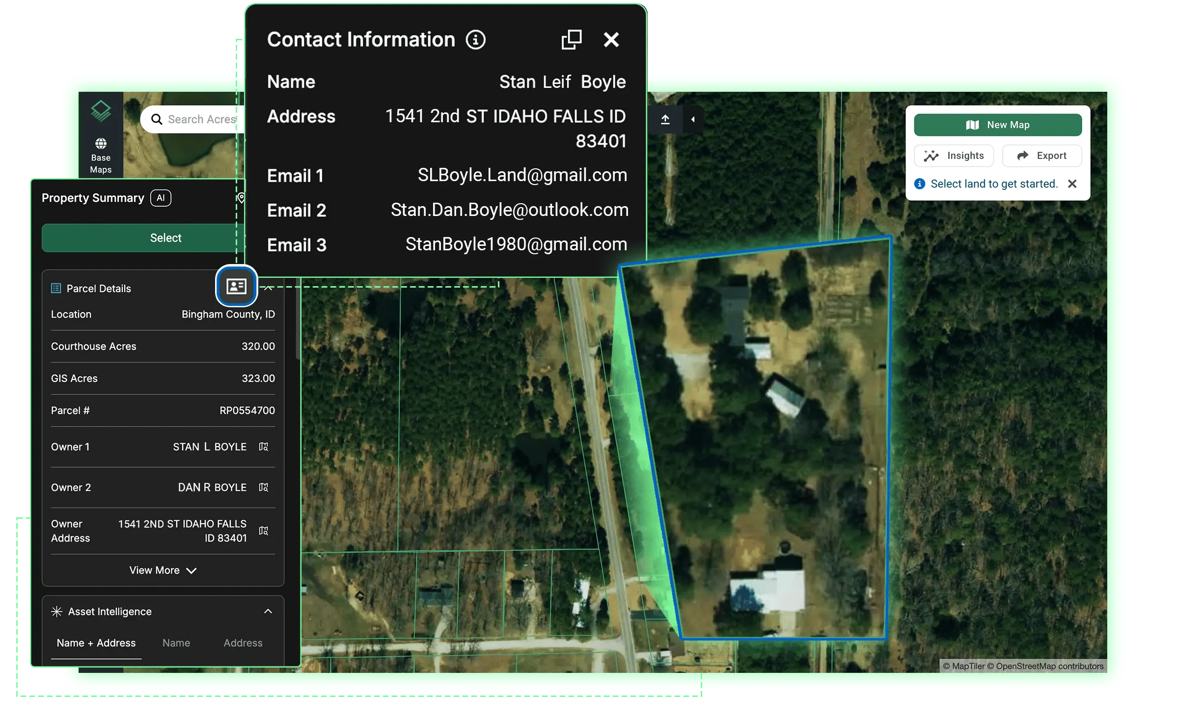
Step 5: Evaluate Ownership Data and Contact the Right Seller
Once a parcel clears your location, zoning, size, and environmental filters, the final step is confirming who owns it and whether it is actually available. Not every parcel worth pursuing will have a listing attached to it. Some of the best land purchases come from direct outreach to owners who have not formally listed the property.
A land listings map view that includes ownership data, deed transfer history, and tax status gives buyers a major advantage here. You can identify parcels that meet all your criteria, find the owner of record, and reach out before the property ever hits the open market. This approach is standard practice among professional land buyers and increasingly accessible to individual buyers as well.
For buyers interested in building a prospecting workflow around map-based search, the land prospecting tools on Acres let you move from map search to owner outreach in a single platform without switching tools.
Turning a Map View Into a Complete Due Diligence Picture
Running these five steps manually across separate platforms, county portals, and state databases takes significant time per parcel. The buyers who move fastest are the ones who have all of this data consolidated in one place. Acres brings ownership, zoning, environmental risk, infrastructure proximity, and comparable sales into a single map view, so the five steps above happen in one session rather than five.
How Acres Makes Land for Sale Map Search More Effective
Acres is built around the way land buyers and professionals actually research property. With data on over 150 million parcels and thousands of datasets that are always up to date, it gives teams the most extensive, complete view of land data in a single system, covering ownership, parcel details, zoning, environmental risks, infrastructure context, and more.
Rather than toggling between a listing platform, a county GIS portal, a FEMA flood map, and a deed search tool, teams can run an entire map-based land search from one place. Describe what you are looking for in plain language and get results instantly. Every parcel you pull up shows the full picture, not just the listing details.
For land teams evaluating multiple parcels across a region, the land mapping and parcel search tools on Acres let you build a shortlist, compare parcels side by side, and move toward a decision faster than traditional listing research allows.
Key Takeaways: Search Land for Sale by Map the Right Way
A map-first approach to buying land is faster, more accurate, and more complete than working through a standard listing feed. Start with a platform that shows parcel boundaries and data, not just listed properties. Set location filters before price filters. Use zoning layers to eliminate parcels that do not fit your intended use. Layer in environmental and infrastructure data before making any offer. Then use ownership records to reach sellers directly when the right parcel is not actively listed.
The more data layers you apply during your land for sale map search, the fewer surprises you encounter during due diligence. That is the difference between buying land with confidence and buying it with uncertainty.
Start Your Land Map Search Today
Explore parcel boundaries, ownership data, zoning layers, and environmental overlays across the entire U.S. Connect with our team to see how you can start streamlining land research with the most extensive land data available.