Finding the right parcel used to mean hours across county assessor databases, recorder offices, and fragmented ownership records. Today, a land map search surfaces ownership details, parcel boundaries, zoning designations, and environmental context in seconds. That coverage spans more than 150 million parcels across the United States. Whether you are prospecting, verifying property lines, or building a site selection shortlist, this guide covers what you need to know.
Acres.com puts all of that data in one place, so you can get answers without bouncing between sources.
Contents
Why Land Mapping Is Harder Than It Looks
How to Search and Map Parcels Online: A Step-by-Step Guide
How Acres Makes Parcel Mapping Faster
The Bottom Line on Land Mapping Online
Why Land Mapping Is Harder Than It Looks
Land data in the United States is highly fragmented. The U.S. had approximately 1.88 million farms covering 876 million acres as of 2024. Property records are maintained at the county level. Most jurisdictions have their own format, update schedule, and access method. County-level parcel viewers vary significantly in the detail they provide, according to USGS. Coverage gaps are especially common in rural and semi-rural markets where land search activity is highest.
For anyone trying to search land at scale, that fragmentation creates real friction. A single land mapping workflow can require pulling parcel boundaries from one source, ownership data from another, and zoning or environmental data from yet another.
Each lookup takes time. Each source uses different identifiers, coordinate systems, and update cadences. By the time all the pieces are assembled, the data may already be out of date.
The answer is not more tabs open. It is a consolidated land mapping system that standardizes and connects every layer in one view.
How to Search and Map Parcels Online: A Step-by-Step Guide
Most parcel searches fail not because the data is unavailable, but because users do not know where to start or what to look for. Follow these steps to run a clean, efficient land map search from scratch.
Step 1: Start With Parcel Boundaries
A parcel is a defined unit of land ownership recorded by a local government authority. Every parcel has a unique identifier, usually called an Assessor Parcel Number (APN) or parcel ID. These identifiers link ownership records, tax data, zoning classifications, and physical boundaries to a single legal unit of land.
When running a land search, start by locating the parcel boundary. This tells you the exact legal footprint of the property: where it starts, where it ends, and what sits adjacent to it. Parcel boundaries are derived from recorded plat maps and deed descriptions maintained by county assessor or recorder offices.
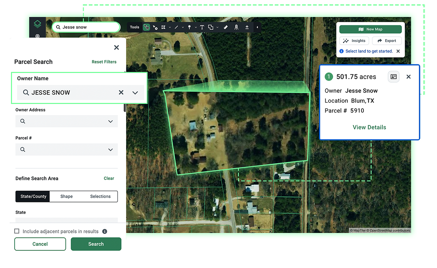
With Acres: Search any U.S. address, APN, or owner name on the Acres parcel map to pull up the boundary, acreage, and ownership context in a single view.
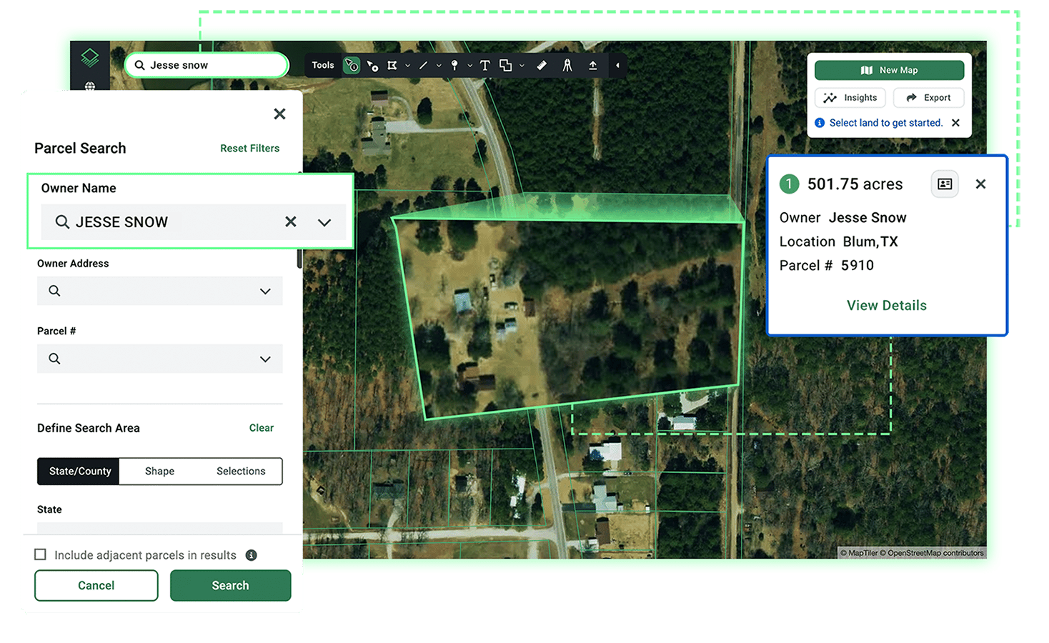
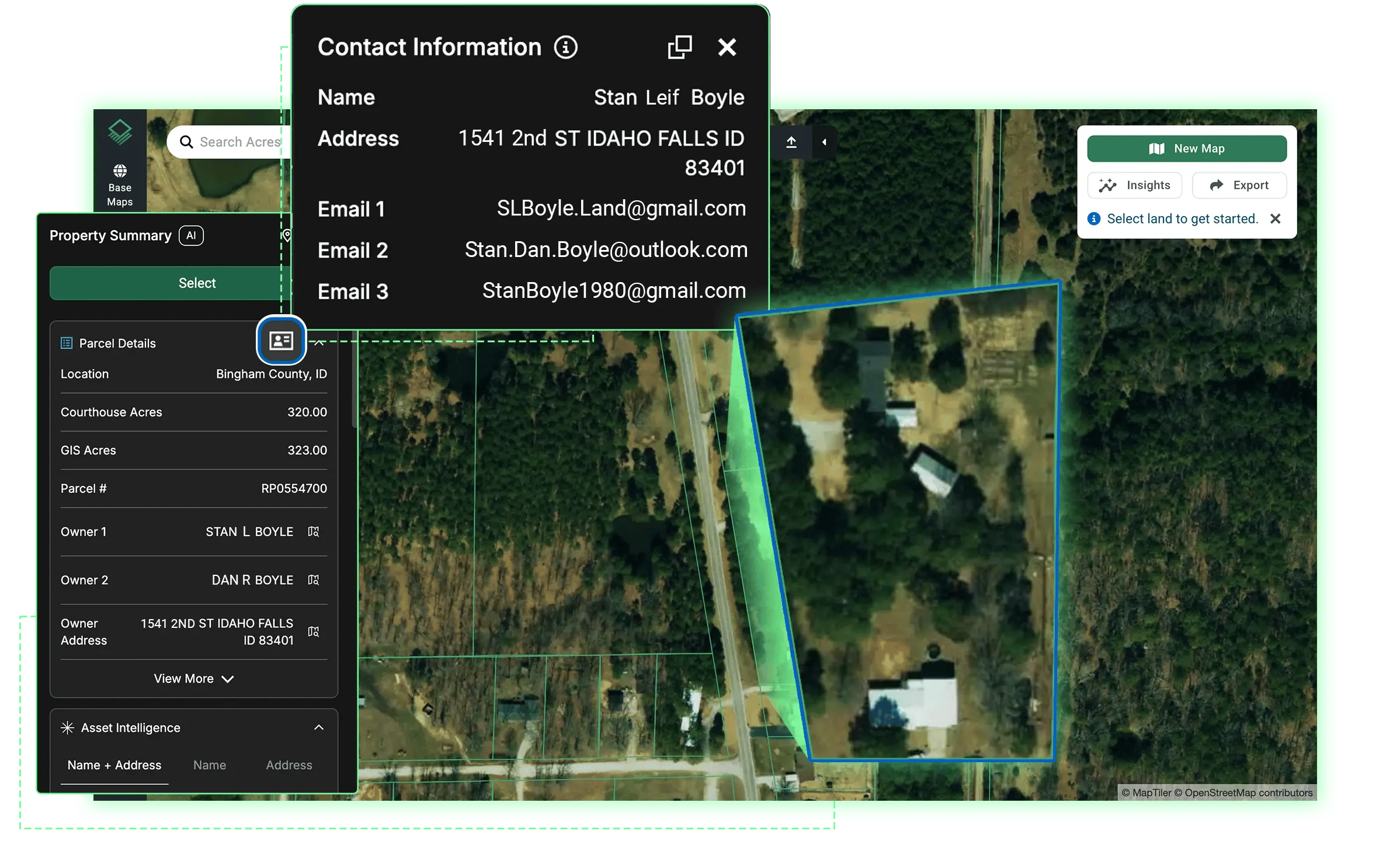
Step 2: Look Up Land Ownership
Once you have the parcel boundary, the next step is verifying who owns the land. Ownership data includes the recorded title holder, their mailing address, and whether the owner is an individual, an LLC, a trust, or another entity. That distinction matters. Institutional owners often have different disposition timelines and motivations than individual landowners, which affects how you approach outreach.
Ownership records are public and filed at the county level. However, they are not always current. Deeds take time to record after a transaction closes, and some counties are slower to update their digital records than others. Reliable land search platforms pull from regularly updated data feeds to minimize that lag.
For land buyers and brokers, the ability to find land by owner name or mailing address is particularly useful. It lets you map an entire portfolio held by one entity or identify absentee owners across a target geography. That is a core prospecting technique for motivated seller outreach.
With Acres: Search by landowner name or address to see all of their land holdings across the U.S. Then, use Asset Intelligence to unmask mortgages and any hidden LLCs or entities behind the parcels.
Step 3: Add Zoning and Land Use Context
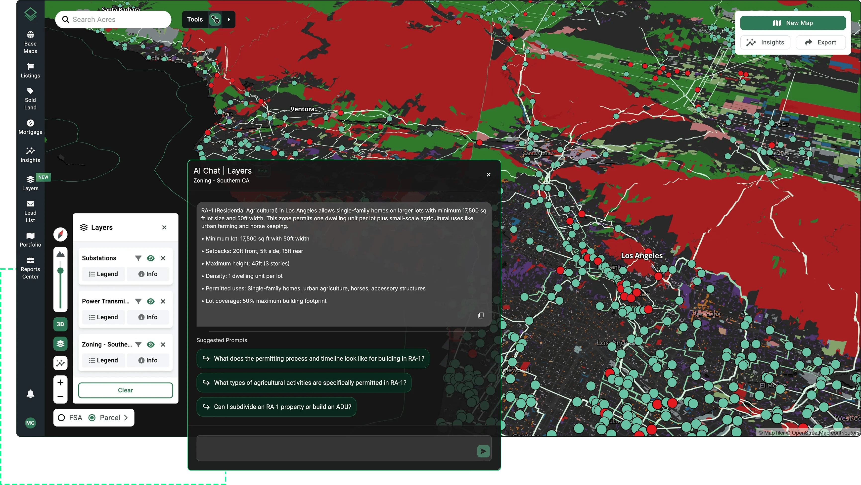
A parcel boundary tells you where the land is. Zoning tells you what you can do with it. Zoning designations govern whether a parcel can be used for residential, commercial, agricultural, industrial, or mixed purposes, and they vary dramatically across jurisdictions.
Zoning data is one of the most fragmented layers in U.S. land records. Rules shift at the township or municipality level and are rarely standardized across county lines.
When running a property map search for due diligence or site selection, layering zoning data over the parcel boundary is a critical step. It can immediately eliminate parcels that do not fit the intended use, saving significant time before any further analysis begins.
With Acres: Access hundreds of county and city zoning layers or use Acres Intelligences’ natural language zoning chat to breakdown specific codes, get information about setbacks, timelines, and requirements, and turn complex zoning codes into actionable clarity.
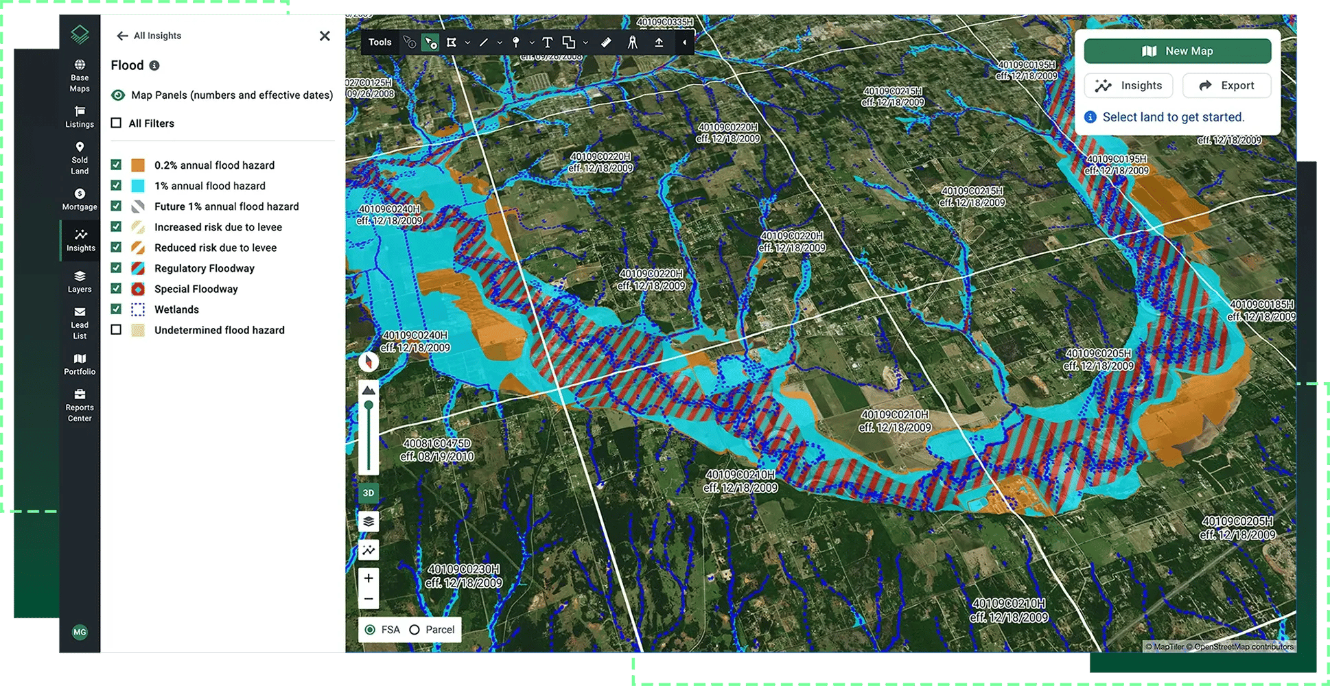
Step 4: Check Environmental and Infrastructure Layers
Parcel boundaries and ownership are only part of the picture. For most land use cases, the surrounding context matters just as much. Environmental factors include flood zone classification from FEMA, wetlands designations, and proximity to protected areas. Infrastructure context includes road access, utilities, power lines, substations, and any easements that may affect development potential.
These data layers are what separate a surface-level property map search from real due diligence. A parcel can look clean on the boundary map and still carry significant constraints once environmental and infrastructure data are applied.
With Acres: Use Acres Layers to toggle flood zones, wetlands, elevation, protected land, utility and power infrastructure, and more, directly over any parcel map. Each layer is built from the most recent, relevant land data available, so you are not working from outdated snapshots.
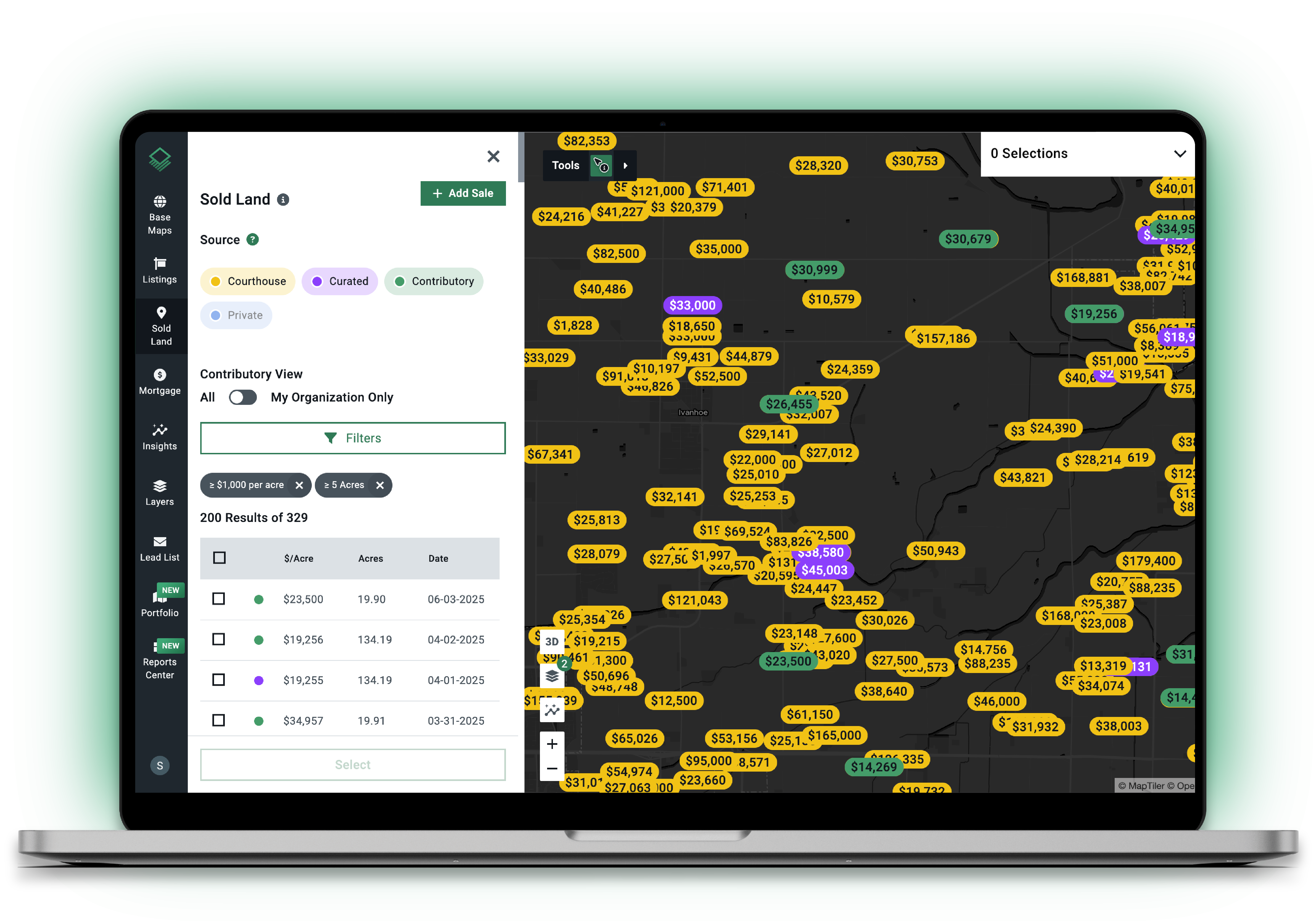
Step 5: Verify Acreage and Run Comps
Recorded acreage figures are not always accurate. Survey-grade measurements can differ from county records, particularly for irregularly shaped parcels or those near bodies of water where boundaries shift over time. Before committing to a parcel map as the basis for valuation or offer, it is worth confirming which acreage figure is controlling in your jurisdiction.
Once acreage is confirmed, comparable sales data adds market context. Running land comps through a parcel search tool shows what similar parcels have transacted for nearby, filtered by acreage range, land type, and sale date.
For regional pricing context, see land values by state and region for what comparable parcels are selling for across different U.S. markets.
With Acres: Use the most extensive, up-to-date land sales data available along with comparable sales for accurate valuation.
Many professionals working in land acquisition, energy site selection, or rural development run some version of this five-step workflow on every deal. The challenge is that sourcing each data layer separately adds hours to every search.
Acres brings ownership, parcel context, zoning, environmental signals, and infrastructure data together in a single system. Teams can move from land map search to a qualified decision in minutes rather than days.
How Acres Makes Parcel Mapping Faster
Acres is built around one idea: land research should not require six different browser tabs and a call to the county office. The platform covers over 150 million U.S. parcels and unifies ownership records, parcel boundaries, zoning, environmental risk flags, and infrastructure data into a single view.
For teams running high-volume land searches, describe what you are looking for and Acres Intelligence surfaces matching parcels, ownership context, and relevant data layers instantly.
Weeks of land research become minutes with complete land data and powerful AI.
For land professionals doing targeted due diligence, the parcel map view gives you boundaries, acreage, ownership, zoning overlays, and environmental layers in one screen. No toggling between platforms. No reassembling data from disconnected sources.
The Bottom Line on Land Mapping Online
Land mapping online has become far more accessible. Even so, the quality of your parcel search still depends on where your data comes from and how well it is connected. Parcel boundaries, ownership, zoning, environmental context, and comparable sales are the five steps that separate a thorough search from a surface-level one.
Fragmented county data remains the biggest obstacle for anyone doing land mapping at scale. The professionals moving fastest have consolidated that workflow into a single platform rather than building it piece by piece. If your team can describe the parcel you need, you can find it, map it, and move toward a decision without leaving the same screen.
Ready to run your first parcel search? Connect with our team and discover how to search land by address, APN, or owner name and pull up ownership, boundaries, and data layers instantly.