Many landowners have no idea what their property is actually worth until they need to sell, refinance, or pay taxes. By then, guessing costs. Whether you own a rural parcel, farmland, or vacant acreage, knowing how to find land value by address gives you a number to negotiate with, plan around, and act on.
This guide walks you through every method available, from county records to professional appraisals. Acres.com pulls the ownership data, comparable sales, and zoning details for any parcel into one place, so you can move from address to estimate without piecing together five different sources.
Why Standard Valuation Tools Fall Short for Land
Land valuation is not the same as home valuation. Automated tools built for residential real estate are calibrated for houses, not raw land. They factor in square footage, bedroom count, and finished improvements. None of that applies to a parcel of bare acreage.
According to USDA ERS data, the average value of U.S. farm real estate reached $4,170 per acre in 2024, but that national figure tells you almost nothing about the value of a specific parcel. Land values vary sharply by state, county, soil productivity, water access, zoning classification, and proximity to infrastructure. A 40-acre tract in Texas and a 40-acre tract in rural Kansas can be priced at entirely different levels.
That gap between general data and property-specific reality is exactly why a structured approach to land valuation matters. Here is how to determine land value by address using tools and data sources built for land, not houses.
How to Find Land Value by Address: 5 Steps
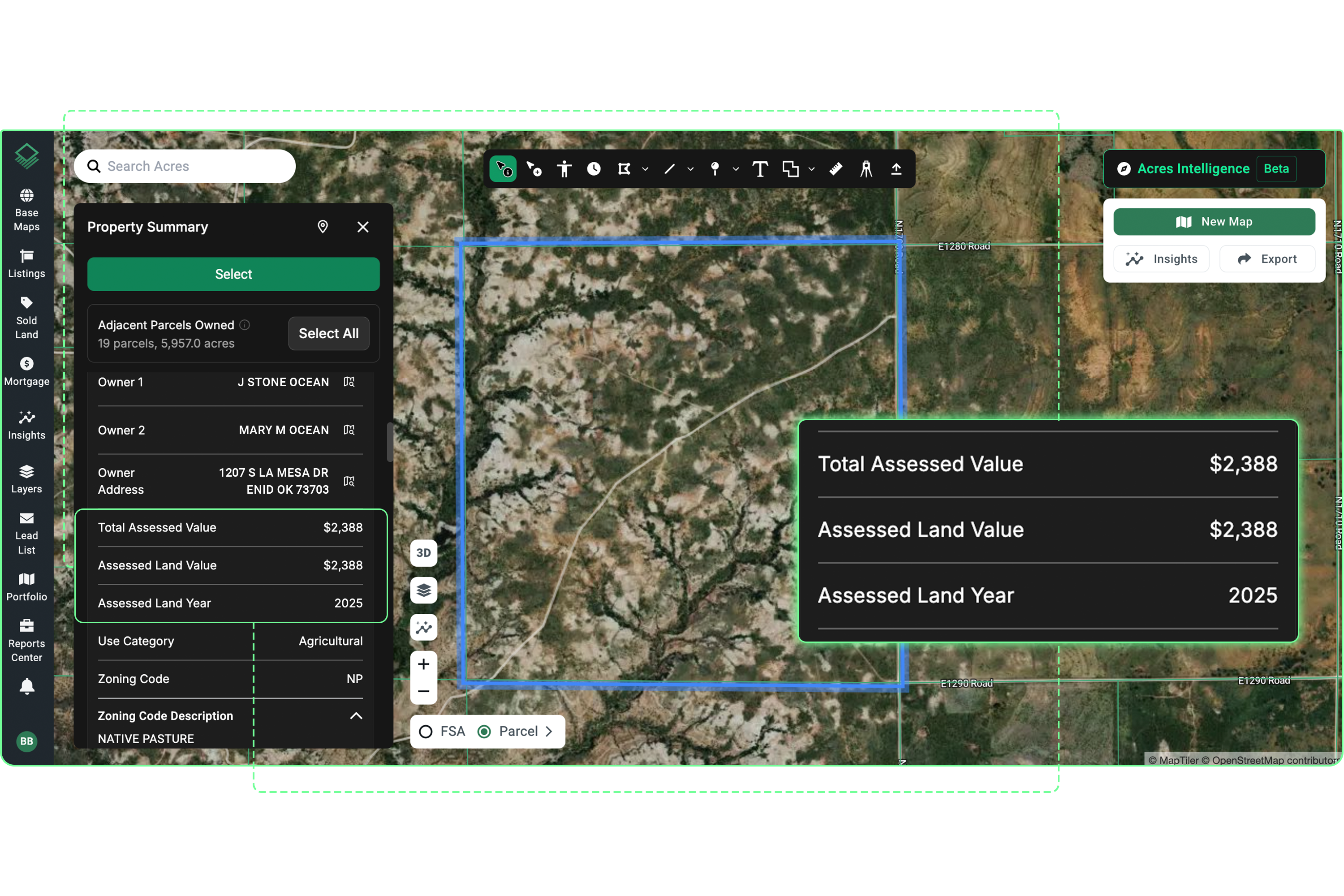
Step 1: Search Your Parcel on Acres to Pull the Full Data Picture
When you want to find land value of a property, the fastest starting point is a platform built for land data—not a residential estimator that strips out everything a parcel-level search needs. Acres covers over 150 million parcels nationwide and surfaces assessed values, ownership records, zoning classifications, acreage, and parcel characteristics in one place.
With Acres:
Enter any address or parcel number and immediately see the assessed land value, acreage, zoning classification, legal description, ownership history, and nearby comparable sales, all in one view. Rather than pulling assessed value from a county portal, zoning from a planning department site, and comps from a deed recorder, Acres brings every data layer into the same parcel card.

Assessed value from county records is a useful baseline, but not a market value. Counties use their own assessment ratios and update cycles. In many jurisdictions, assessed value runs 70 to 90% of actual market value, and in some rural areas it lags further behind. Use it as a floor, not a ceiling.
Step 2: Build a Comparable Sales Set
The most reliable method for answering what is my land worth is to find what similar parcels have actually sold for recently. This is the same comparable sales method appraisers use, and it works because buyers and sellers set market prices—not tax offices.
When searching for comps, match on:
- Land size - within 20 to 30% of your acreage
- Land use type - agricultural, recreational, timber, or residential development
- Location - land values by zip code can vary significantly even within one county
- Sale date - within the past 12 to 18 months, ideally
In non-disclosure states, deed transfer prices are not always public, which means a data provider that aggregates transaction records across public sources is the most practical way to build a usable comp set. Acres consolidates parcel-level sales data alongside ownership and zoning so you can qualify comps without switching between county databases.

Step 3: Use a Land Value Estimator Built for Raw Land
Online land valuation tools vary widely in quality. A reliable land value estimator pulls from recorded deeds, tax assessments, soil data, zoning layers, and recent sales to generate a property-specific estimate, not just a zip code average.
When evaluating any land appraisal calculator or land value calculator, check whether it:
- Uses actual comparable sales, not just assessed values or list prices.
- Separates land value from structure value.
- Accounts for parcel-specific factors like flood zone status, soil capability, and road access.
- Covers rural and agricultural parcels, not just residential lots.
Tools built primarily for residential real estate will underperform on rural acreage. Soil productivity data from USDA NRCS, FEMA flood zone designations, and local market transaction records are the data layers that move the needle on land valuation.
For more on how comparable sales drive land valuation, see land valuation tools on Acres.
Step 4: Factor In What Makes Your Land Unique
Any land value calculator gives you a starting point. What you do with site-specific details determines accuracy. Before you finalize an estimate, consider the following:
- Soil quality: USDA Web Soil Survey assigns productivity ratings by soil type. Higher-rated soils on agricultural land command meaningful premiums.
- Water access: Irrigation rights, stock ponds, and creek frontage add value in most markets. In the West, water rights can represent a substantial share of total land value.
- Access and road frontage: A landlocked parcel is worth a fraction of one with direct road access. Flag any easement issues before valuing.
- Zoning and development potential: Land zoned for commercial or residential development in a growing area is priced on different logic from agricultural-zoned rural ground.
- Timber and mineral rights: If you own subsurface mineral rights or standing timber, factor those in separately.
Always verify flood zone status before finalizing any estimate. Parcels in FEMA Special Flood Hazard Areas carry real restrictions on development and financing that reduce both usability and market value.
Rather than pulling soil data from USDA NRCS, flood zone information from FEMA records, and ownership history from a county assessor portal separately, Acres consolidates ownership, parcel characteristics, zoning, and land data into one connected view, so you can factor in every variable before committing to a number.
Step 5: Back It Up with a Formal Appraisal for High-Stakes Decisions
If you are preparing to sell, buy, finance, or settle an estate and the dollar amounts are significant, a licensed land appraiser is worth the cost. A certified appraisal carries legal and lender standing that self-service tools do not.
A formal appraisal typically runs $300 to $1,500 depending on acreage, complexity, and location. The appraiser will pull comps, conduct a site visit, analyze soil and zoning, and produce a written report that supports the value conclusion. For tax appeals, financing applications, or litigation, this is the document that holds up.
How Acres.com Supports Land Valuation by Address
Acres brings together the data layers that actually drive land value: ownership records, soil productivity, zoning classifications, flood zone status, and transaction history for over 150 million parcels across the country.
Instead of entering parcel details into multiple separate tools, land buyers, sellers, and professionals use Acres to search by address or parcel number and see the full picture in one place: assessed values, comparable sales, parcel characteristics, and zoning context. Weeks of manual research become minutes. For anyone making frequent valuation decisions, that speed and data depth translates directly into faster deal qualification and more confident pricing.
Getting to a Number You Can Use
Finding land value by address requires more than plugging a parcel into a residential estimator. Start with a land-specific platform to pull assessed value, ownership records, and zoning in one search. Build a comparable sales set from recent transactions in your sub-market, use a land-specific valuation tool to layer in soil and environmental data, and account for site-specific factors that move value up or down. For high-stakes decisions, back it up with a licensed appraisal.
The clearest signal of what your land is worth is what buyers have actually paid for similar ground, recently, nearby, and under comparable conditions. Build your estimate from that foundation, and you will have a number worth acting on.
Ready to see your parcel's full data profiles? Contact our team to see how.