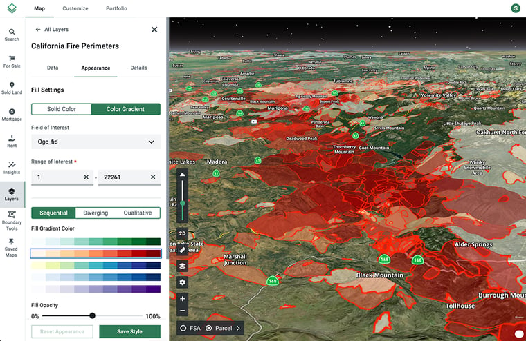
Fire perimeters, the defined boundaries of areas affected by wildfires, provide valuable insights into the history and frequency of fire activity in a region. For developers and builders, knowing how to interpret these maps isn't just about compliance with state regulations, it’s about making informed decisions that protect lives, properties, and investments.
In this Map Feature, we’ll explore how Acres’ Layer Library can be utilized to elevate more sustainable developments in wildfire-prone areas.
Map of California Fire Perimeters
Acres' interactive California Fire Perimeters Map offers detailed data, including acreage, frequency, alarm dates, and more.
We provide historic fire perimeter mapping with the latest data available from 2023. This data is updated annually in April as California wildfire threats persist.

Acres’ California fire perimeters data is derived from the California Department of Forestry and Fire Protection.
Considerations for Developers
Development in wildfire-prone zones requires adherence to specific guidelines and regulations. While local regulations may vary between municipalities, here are general considerations:
- Fire Hazard Severity Zones (FHSZ): State acknowledged zones require specific regulations and offer mitigation plans for infrastructure protection.
- CAL FIRE Guidelines: Comply with the California Department of Forestry and Fire Protection (CAL FIRE) requirements, including defensible space and vegetation management.
- Building Codes: Follow California’s Wildland-Urban Interface Building Code, which mandates fire-resistant materials for roofs, siding, windows, and decks.
- Cost of Compliance: Account for potentially higher insurance, construction, or maintenance costs due to compliance with fire safety standards.
- Ongoing Risk Management: Implement ongoing fire mitigation strategies, such as vegetation management and periodic inspections.
Considerations for Buying Land
Buying land in fire-prone areas face unique challenges that fire perimeter maps can help address:
- Loss or Damage Risk: Property within and around fire perimeters are at higher risk of destruction or damage by flames, heat, ash, and smoke.
- Insurance Challenges: Sufficient coverage may be difficult to obtain, forcing homeowners to seek coverage through options like the California FAIR Plan.
- Increased Premiums: Risky locations lead to higher insurance costs.
- Infrastructure Damage: Utilities like water, electricity, and gas can be disrupted, sometimes for extended periods.
- Property Values:Properties in wildfire zones may experience reduced land value due to perceived risk.
Final Thoughts
For developers and landowners alike, fire perimeter maps are invaluable. They’re not just tools, they’re guides to safer, more informed decisions. Acres’ Fire Perimeters Map is a free resource available to every one, offering the data and insights needed to navigate wildfire risks.
