A parcel next to a transmission line can still have no usable substation capacity. That is where many data center site selection mistakes start. Here is how to tell the difference.
-Sep-17-2026-05-05-00-1809-PM.png)
A parcel next to a major transmission line can still have zero usable substation capacity, and that distinction is where many site selection mistakes start. A parcel adjacent to a transmission corridor is not, by itself, close to power. It is close to an infrastructure pathway that may or may not have access points with available capacity nearby.
While a transmission line can technically be tapped by constructing a new dedicated interconnect substation, the line itself may lack available thermal capacity, system stability headroom, or interconnection queue availability. The site screen that uses physical transmission line proximity as a proxy for energized power access is measuring the wrong variable.
This is one of the most costly errors in data center site selection. It produces candidate pipelines that appear well-positioned, only to fail during utility due diligence. In many cases, the nearest substation with available capacity is miles away, fully committed, situated in a grid zone that is thermally congested and queue-blocked, or requires years of network upgrades.
Understanding exactly why these two signals diverge and how to evaluate each correctly is the foundation of reliable power due diligence. Acres.com gives development teams the parcel-level infrastructure data to distinguish genuine power proximity from line proximity on any candidate site nationwide.
Contents
Why Do Transmission Lines and Substation Capacity Send Different Signals?
What Does the Distinction Look Like in a Real Site Screen?
Comparing Grid Signals: Transmission Corridors vs. Substation Nodes Table
Why Is Substation Capacity So Often Misread?
How Do You Correctly Evaluate Power Access in Due Diligence?
How Acres Supports Correct Power Proximity Screening
Why Do Transmission Lines and Substation Capacity Send Different Signals?
Proximity to infrastructure is not the same as access to capacity. That distinction separates viable sites from aspirational ones.
The transmission system moves power across long distances. Transmission lines are the backbone of the grid, connecting generating plants to the regional distribution system. They are visible, mappable, and appear on GIS overlays as clear indicators of grid infrastructure.
Substations are the transformation points where transmission voltage is stepped down to voltage levels that can be delivered to end users. A substation connected to a 230 kV transmission line converts that power to the 2.4 kV to 35 kV range that feeds industrial customers and eventually, through additional transformation, residential neighborhoods.
For large-scale data centers, this transformation either occurs at a nearby utility substation or via a dedicated, on-site substation tapping the high-voltage line directly.
In 2026, a site can sit near a substation, look strong on utility service maps, and still fail because the surrounding grid cannot absorb a new 100 megawatt, 300 megawatt, or 1 gigawatt load without years of network upgrades. Power diligence has traditionally focused on local utility capacity, substation proximity, voltage class, available feeder capacity, and interconnection timing. Those still matter, they are just not sufficient alone.
.png?width=1200&height=628&name=Hubspot%20Blog%20Feature%20Image%20(14).png)
What Does the Distinction Look Like in a Real Site Screen?
Consider a 200-acre parcel in a secondary market. A GIS overlay shows a 345kV transmission line running along the parcel's southern boundary. A site selection team using transmission proximity as a power access indicator would rate this site highly. The correct evaluation runs differently.
Identify whether the project will connect to an existing substation or require a direct line tap for a new dedicated substation. If connecting to existing infrastructure, physical distance to the substation determines immediate connection cost. If tapping the line directly, the critical variable shifts from physical distance to the transmission line's available carrying capacity (MVA/MW) and voltage class.
Available capacity is not a visible characteristic. A substation can appear identical in satellite imagery whether it has 200 megawatts of available load headroom or zero. Available capacity requires utility engagement to confirm, specifically a formal capacity inquiry or a preliminary feasibility discussion with the serving utility. Substations in constrained markets may have zero available capacity regardless of how much transmission infrastructure surrounds them.
Comparing Grid Signals: Transmission Corridors vs. Substation Nodes Table
| Diligence Factor | Transmission Line Proximity | Substation Capacity |
| Grid Function | Bulk power transit corridor passing through or near the parcel. | Physical node for voltage transformation and local load delivery. |
| Power Access Viability | Identifies a potential tap location, but requires thermal headroom and queue clearance. | Confirms physical proximity, but load availability depends on transformer capacity. |
| Common Pitfall | Treating physical line proximity as guaranteed, actionable power access. | Treating substation adjacency as confirmed load availability. |
| Key Screening Question | Does this transmission circuit have thermal headroom and queue space for a new tap? | What is the confirmed, available load headroom (MW) at this node? |
Why Is Substation Capacity So Often Misread?
Utility interconnection and power availability costs range from $5 million to $30 million for standard builds, depending on proximity to lines, easements, and required transformer capacity. However, in power-constrained markets, total costs including network upgrades and transmission extensions can climb to $40 million to $60 million or more (and up to $100M+ for large hyperscale campuses).
In dense markets, buildable acreage with existing high-voltage access is scarce enough that some operators pay a premium for proximity to power rather than lower land cost.
Utility capacity data is not publicly available in real time. A GIS layer showing substation locations does not carry capacity or load data, rather, that information lives in utility planning that is not publicly searchable. Developers who do not have a direct utility relationship in a specific market cannot know substation capacity from map data alone.
A parcel might look perfect on a standard map: flat topography, the right size, and zoned correctly. However, if that parcel is miles away from a substation with available capacity, or if it sits in a transmission congestion zone, it is effectively useless for a hyperscale facility. The gap between 'land available' and 'power available' is where projects stall and capital is lost.
How Do You Correctly Evaluate Power Access in Due Diligence?
A power-ready site in 2026 needs a diligence file that includes current and forecasted load in the service territory, planned transmission upgrades affecting the zone, substation transformer capacity, and queue congestion. The difference is often not whether power exists. It is whether the delivery path is financeable, permitted, and available on the project's timeline.
In practice, correct power due diligence for a data center site runs in three stages. The first stage (which should happen before any letter of intent) is infrastructure mapping: identify the serving utility, locate the nearest substations on any transmission lines in the area, and confirm their voltage class. This is a GIS and desk research exercise that does not require utility engagement.
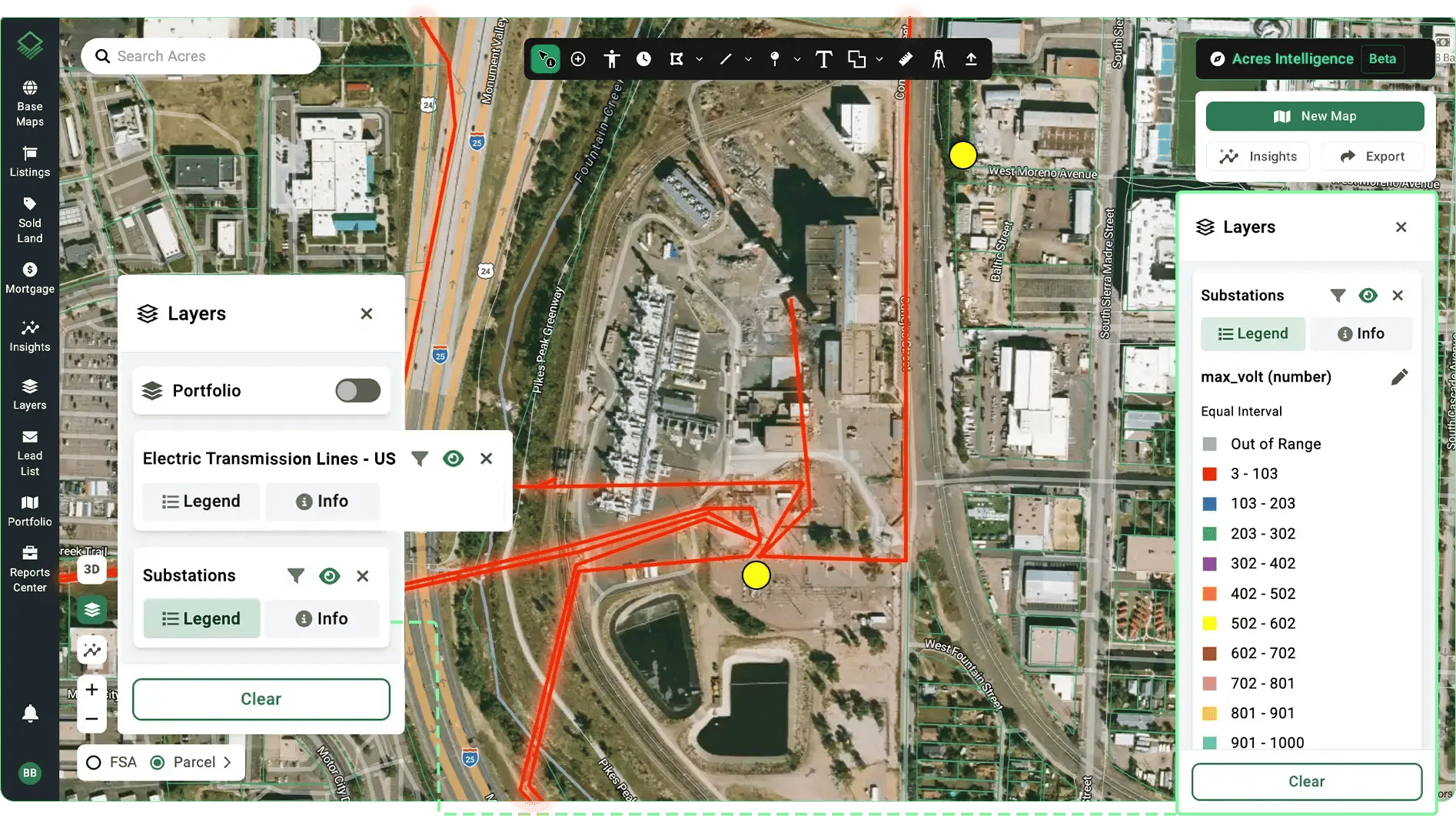
The second stage is preliminary capacity screening: a direct inquiry to the serving utility asking about available load headroom at the identified substation. Most utilities will respond to a preliminary capacity question without a formal interconnection application. The response tells you whether the substation can serve the project scale and what the preliminary interconnection timeline looks like.
The third stage is a formal interconnection feasibility study, which provides engineering confirmation of capacity and identifies any required network upgrades. This is the stage that confirms cost and timeline with enough specificity to be included in a project's financial model.
Acres surfaces parcel-level substation adjacency signals and infrastructure proximity context that give site selection teams the preliminary screen they need to differentiate genuine power proximity from line proximity before utility engagement begins. The first stage of correct power due diligence runs in a single Acres session rather than a multi-source research process.
How Acres Supports Correct Power Proximity Screening
The distinction between transmission line proximity and substation capacity is only identifiable at the parcel level: which substation is actually closest to this parcel, and is that substation positioned to serve a large load? Acres gives data center development teams access to the most extensive, complete view of land data in a single system—parcel boundaries, ownership records, infrastructure proximity signals, zoning, and environmental context—for over 150 million U.S. parcels. See a complete, connected view of ownership, risk, and opportunity, instantly. Explore infrastructure proximity and substation screening on Acres.
|
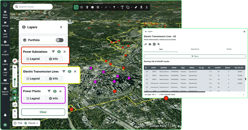
With Acres: Acres surfaces parcel-level infrastructure proximity signals—substation adjacency, transmission corridor mapping, utility easement presence, and environmental risk context—alongside parcel boundaries and ownership records for any U.S. geography. For site selection teams distinguishing transmission proximity from genuine substation capacity access, Acres identifies which candidate parcels sit in viable substation proximity before formal utility engagement begins. |
The Correct Screen Is Substation Capacity, Not Just Line Proximity
Transmission line proximity is a necessary but not sufficient condition for data center power access. A parcel adjacent to a high-voltage transmission line is potentially well-positioned for grid connection, but only if a substation with available capacity is within viable distance, and only if that substation's capacity can be confirmed before capital is committed to the site.
The site selection teams that avoid the transmission-proximity-as-power-access error are the ones that run substation identification and preliminary capacity screening before any other infrastructure analysis. That sequencing does not require formal utility engagement at the first stage, it requires parcel-level infrastructure proximity data that shows which substations are actually closest to each candidate site. Getting that preliminary screen right is how development teams can avoid committing time and capital to sites that fail power due diligence.
Ready to run a substation proximity screen on data center candidate sites in your target markets? Surface infrastructure proximity, parcel ownership, and zoning context for any U.S. geography on Acres. Book a demo and start your power proximity screen on Acres.