Infrastructure proximity is the measurable distance between a parcel and the roads, utility lines, substations, and development corridors that determine what the land can be used for and what it is worth. Across energy, utility, and residential development markets, proximity to the right infrastructure is the variable that separates raw land priced at agricultural rates from land priced at a multiple of that baseline.
The premium appears in transaction data across major land use categories: energy provider sites paying more per acre near high-voltage substations, homebuilders paying more for serviced lots versus raw acreage, and industrial buyers paying more for parcels within viable distance of transmission corridors.
Acres.com surfaces infrastructure proximity signals at the parcel level across 150 million+ U.S. parcels so buyers and sellers can analyze opportunities before any offers are made.
Contents
Why Infrastructure Proximity Moves Land Prices More Than Acreage
What Does Substation Proximity Actually Do to Land Price?
Infrastructure Type - Land Value Premium Summary Table
How Does Road and Highway Access Change What Land Is Worth?
What Utility Access Adds to Residential and Development Land
How Planned Infrastructure Reprices Land Before It Is Built
How Acres Surfaces Infrastructure Proximity for Any Parcel
Not All Infrastructure Premiums Are Created Equal
Why Infrastructure Proximity Moves Land Prices More Than Acreage
Land is fixed in location and variable in usability. Two 100-acre parcels in the same county can sell for orders of magnitude different prices not because of what they are, but because of what is near them. A parcel adjacent to a high-voltage substation with available load capacity is a fundamentally different asset from an identical parcel two miles away with no transmission access, even if they share the same soil type, zoning classification, and acreage.
Infrastructure converts raw land into usable land, and usable land commands a premium over raw land across most markets. The infrastructure type determines the buyer category, and the buyer category determines the magnitude of the premium.
Energy providers, solar and wind developers, and battery storage operators pay premiums for substation proximity that residential developers do not. Homebuilders pay premiums for road-served, utility-connected lots that timber investors do not. The same physical principle—infrastructure creates usability, usability creates value—plays out differently in each market.
Understanding which type of infrastructure drives a premium for a specific parcel is the first step in pricing it correctly, marketing it to the right buyer, or identifying an underpriced acquisition before the market reprices it.
What Does Substation Proximity Actually Do to Land Price?
Among major infrastructure types, high-capacity electrical power infrastructure has emerged as one of the fastest-growing drivers of land value premiums in recent years. The demand is accelerating from providers such as solar developers, battery storage operators, independent power producers, and increasingly, data center operators who all need confirmed grid access as a primary site requirement.
Institutional analysis of power-adjacent land transactions shows that buyers value confirmed utility capacity at a premium of roughly $150,000 to $400,000 per megawatt of committed capacity, depending on market tier, entitlement status, and contractual certainty. That per-megawatt framework means the land value premium is directly tied to how much confirmed power the parcel can access, not just its physical distance from a substation.
The premium is not evenly distributed across distances. A parcel directly adjacent to a substation with available load headroom is a different asset category from a parcel a mile away from a fully committed substation, even if a distance-only screen treats them as equivalent.
For energy providers specifically, the value of substation proximity compounds when the substation supports the voltage level needed for the intended project. Solar and wind projects typically connect at 69kV to 230kV. Utility-scale battery storage often connects at distribution voltage. The match between the project's technical requirements and the substation's available voltage level determines whether the proximity translates into a usable site, and therefore, whether the land value premium applies.
The secondary driver is transmission corridor access. Parcels within viable distance of existing high-voltage transmission lines carry a premium when energy developers can model a cost-effective interconnection path. Undeveloped corridors often see speculative price increases once a utility announces a transmission investment program in a region, because land buyers price in future access before construction begins.
Infrastructure Type - Land Value Premium Summary Table
|
Infrastructure Type
|
Primary Buyer
|
Typical Value/Premium Impact
|
Key Proximity Factor
|
|
High-voltage substation
|
Energy providers, solar, storage
|
Substantial Multiplier (Commanding peak per-megawatt capacity premiums)
|
Available capacity + interconnection timeline
|
|
Transmission corridor access
|
Renewable energy developers
|
Moderate to High Premium over agricultural baseline
|
Voltage level match to project requirements
|
|
Major highway frontage
|
Commercial, industrial, logistics
|
Significant Lift over off-highway comparables
|
Road frontage feet + interchange proximity
|
|
Water/sewer utility connection
|
Homebuilders, residential developers
|
Direct Cost Offset (Per-lot valuation differential over raw land)
|
Distance to line + capacity available
|
|
Fiber corridor access
|
Data centers, enterprise tenants
|
Targeted Premium in supply-constrained tech markets
|
Carrier diversity + route redundancy
|
|
Planned development corridor
|
Residential, mixed-use developers
|
Speculative Uplift upon project announcement
|
Entitled vs. raw land differential
|
Note: Infrastructure value impacts represent general market trends and can vary based on parcel size, local zoning, entitlement status, available utility capacity, and specific buyer requirements. This analysis is for informational purposes only and does not constitute a formal appraisal or financial advice.
How Does Road and Highway Access Change What Land Is Worth?
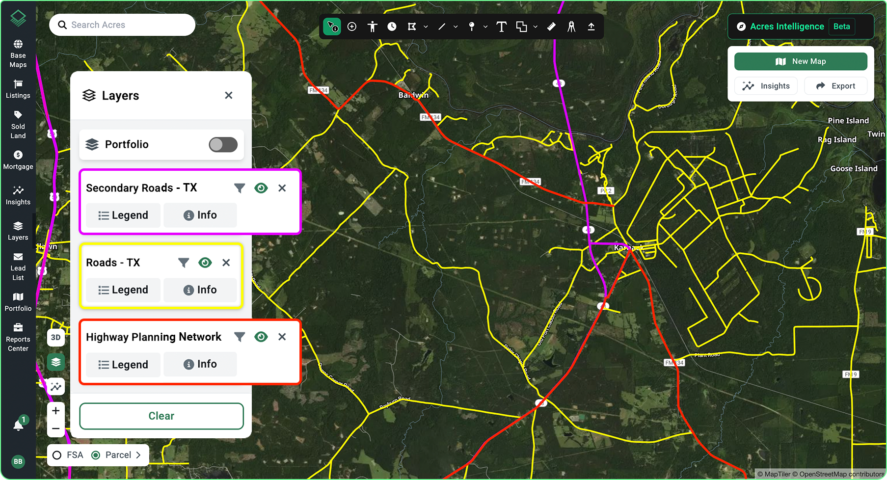
Road access is the most universal infrastructure premium. It applies across nearly every land use category because a parcel without legal road access is difficult to finance, develop, or market to standard buyers. The value differential for road-served land over landlocked land can reach 50% to 100% or more in rural markets, particularly where establishing legal access through easement negotiation or road construction is cost-prohibitive.
Within the road-access premium, highway proximity creates a secondary tier. Documented cases show parcels near planned transportation infrastructure can increase in asking price by 50% or more on announcement of the project, before a single shovel of construction begins. The mechanism is buyer anticipation of improved access and demand.
Highway frontage versus highway proximity produces different premiums in commercial and industrial land. A parcel with direct frontage on an interstate interchange commands a substantial premium over a parcel one mile off-highway in the same market. For logistics and distribution uses, that highway visibility and truck access translates directly into operational efficiency that buyers price in.
For residential land, the highway premium inverts at close range. Land within a certain distance of a major highway sees a noise and air quality discount that can offset the accessibility premium. The net value effect of highway proximity for residential parcels is positive at moderate distances—within driving range of an interchange but not adjacent to the road itself.
What Utility Access Adds to Residential and Development Land
For land that homebuilders and residential developers evaluate, utility access is an infrastructure variable that directly determines the cost of development and therefore the price they are willing to pay for land.
For example, a raw parcel that requires a $60,000 utility extension before a single foundation can be poured is worth $60,000 less to a homebuilder than an otherwise identical parcel where water and sewer sit at the boundary.
Because utility-served parcels eliminate those costly infrastructure extensions, they command a strong value premium over raw acreage. Having water and sewer available at the property boundary represents a material savings that flows directly into a buyer's land acquisition model.
|
With Acres:
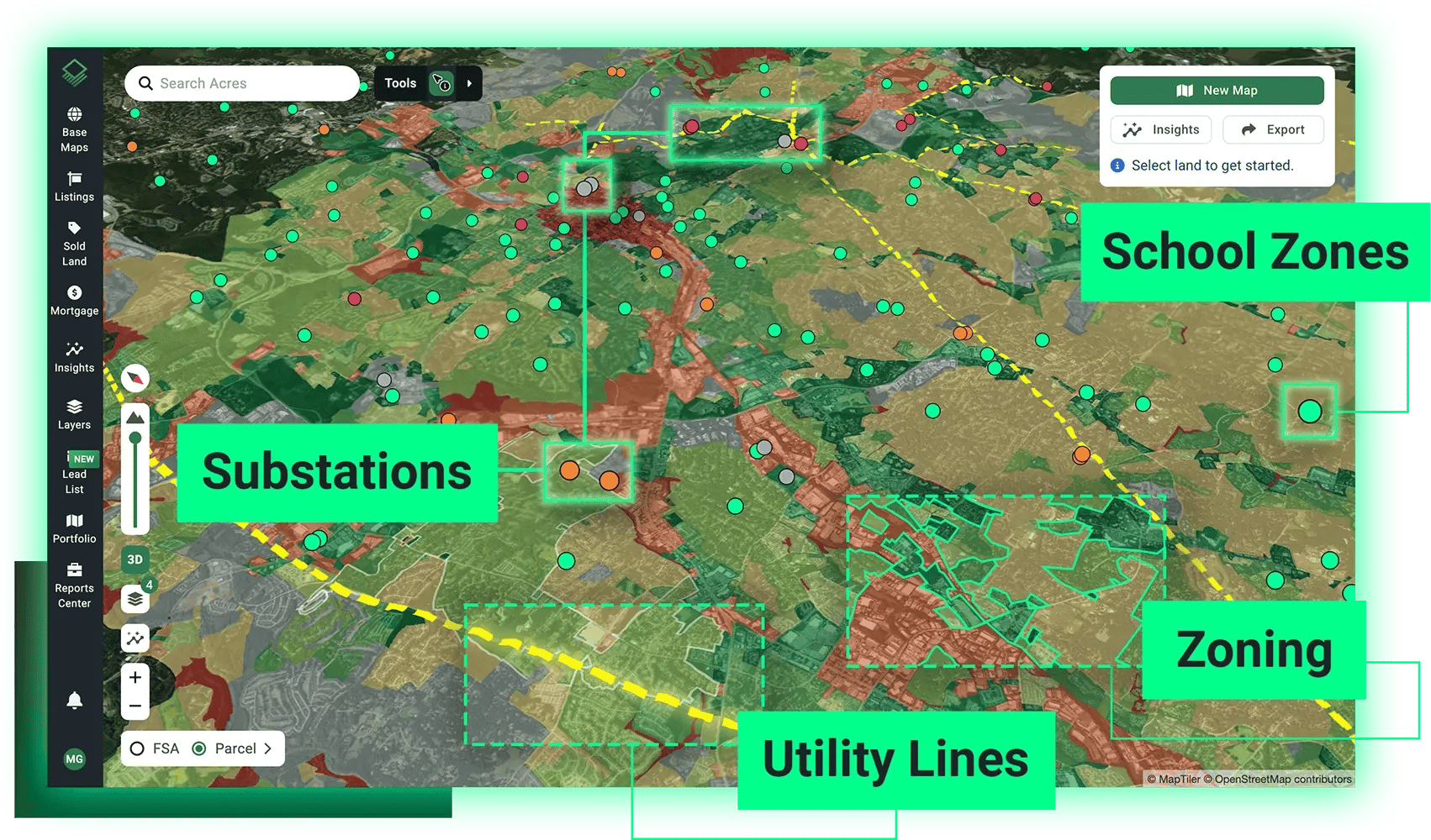
Acres surfaces infrastructure proximity signals including substation adjacency, transmission corridor presence, road access, utility easements, and fiber routes—alongside parcel boundaries, zoning, and ownership data in a single map view. For energy providers, developers, and investors evaluating which parcels carry which infrastructure premiums, the Acres infrastructure proximity layers show what the land can access before formal utility engagement begins.
|
How Planned Infrastructure Reprices Land Before It Is Built
Land prices begin repricing when infrastructure investment is announced, not when it is completed. A utility announcing a substation upgrade, a highway department announcing a new interchange, or a municipality announcing a utility extension into a growth corridor all trigger land price adjustments in the affected geography.
The degree of repricing depends on the announcement. For buyers and analysts tracking land values, reading the infrastructure announcement signal ahead of the broader market is a primary mechanism for finding underpriced parcels.
Parcels in the path of a committed infrastructure investment that have not yet been repriced represent the window between signal and market response where acquisition advantage exists. That window is visible in the data: in transaction velocity, price per acre movement, and infrastructure corridor mapping.
How Acres Surfaces Infrastructure Proximity for Any Parcel
Infrastructure proximity premiums are only as actionable as the data that surfaces them. Acres gives energy providers, developers, and investors access to the most extensive, complete view of land data in a single system—parcel boundaries, ownership records, zoning classifications, environmental signals, and infrastructure proximity context—for over 150 million U.S. parcels.
See a complete, connected view of ownership, risk, and opportunity, instantly. Explore infrastructure proximity and land analysis on Acres.
For energy providers running substation proximity screens across secondary markets, for homebuilders evaluating utility access on candidate lots, and for investors identifying parcels in the path of announced infrastructure investment, parcel-level infrastructure context on Acres surfaces the signal before the market reflects it in price.
Not All Infrastructure Premiums Are Created Equal
The infrastructure proximity premium varies by infrastructure type, buyer category, and the specific match between the parcel's access profile and the buyer's technical requirements. Substation proximity matters most to energy providers. Road access and utility service matter most to homebuilders. Transmission corridor access matters most to renewable energy developers.
In nearly every case the premium is driven by the same underlying mechanism: infrastructure converts raw land into usable land, and usable land commands a premium over raw land.
Understanding which infrastructure type drives a premium for a specific parcel and whether that premium is already reflected in the asking price, is what separates buyers who find underpriced land from those who pay full price for a premium that is already baked in.
Ready to evaluate infrastructure proximity for parcels in your target market? Surface substation adjacency, utility access, road frontage, and comparable transaction data for any U.S. parcel on Acres. Start your infrastructure proximity analysis on Acres.
-Aug-12-2026-09-49-04-9332-PM.png)