The site readiness gap is the disconnect between land that is marketed as data-center-ready and land that passes the actual infrastructure tests a data center developer requires before committing capital. Many parcels fall into this gap: they have acreage, they have a general zoning category that permits data centers, and they are priced accordingly, but they cannot deliver power on a viable timeline, they lack transmission infrastructure, or their permitting path carries unresolved risk.
The gap exists across many U.S. markets and it is widening. Power availability has replaced location as the primary filter in data center site selection, and the supply of parcels that genuinely clear the power test is far smaller than the supply of parcels listed as suitable. Acres.com gives data center development teams the parcel-level data to run the real infrastructure tests before due diligence resources are committed.
Contents
Why Does the Site Readiness Gap Persist?
What Does 'Data-Center-Ready' Actually Mean?
How Development Teams Are Closing the Site Readiness Gap
How Acres Supports Data Center Site Qualification
The Site Readiness Gap is a Data Problem
Why Does the Site Readiness Gap Persist?
The data center market is under extraordinary supply pressure. Primary market vacancy in North America fell to a record-low 1.9% at year-end 2024, with almost no large-scale unoccupied inventory remaining in established hubs. That scarcity is forcing developers to evaluate secondary and tertiary markets—geographies where land is available but where the infrastructure maturity of primary markets does not exist.
The result is a seller's market for land with any data center adjacency. Parcels near transmission lines, near substations, or in markets with favorable zoning are being marketed as data-center-ready regardless of whether the developer has confirmed power capacity, obtained utility engagement letters, or verified the actual permitting timeline. The listing represents aspiration, not diligence.
The financial consequences are real. An estimated $64 billion worth of U.S. data center projects have been canceled or delayed since 2023 due to permitting failures, community opposition, and infrastructure shortfalls identified after capital was already committed. Most of those failures originated in the site selection phase, when parcels passed a surface-level review but failed a deeper infrastructure test.
The site readiness gap is not a marketing problem. It is a data problem.
Development teams that rely on listing descriptions and county zoning maps to qualify sites are working with the same information available to every other buyer. The teams that find genuinely viable sites faster are the ones running infrastructure proximity analysis at the parcel level before anyone else.
-Jul-21-2026-04-23-31-3841-PM.png?width=800&height=419&name=Hubspot%20Blog%20Feature%20Image%20(2)-Jul-21-2026-04-23-31-3841-PM.png)
What Does 'Data-Center-Ready' Actually Mean?
A parcel qualifies as genuinely data-center-ready when it passes five independent infrastructure tests, not just one or two.
Power availability. The single most important filter. The parcel must have confirmed available load from the utility, a defined interconnection timeline (ideally under 24 months to energization), and a cost-of-service estimate for the substation tie-in. A parcel near a transmission line is not the same as a parcel with confirmed available capacity. AI-focused hyperscale developments require 100 to 500 megawatts or more, and grid interconnection queues in many regions extend three to five years. Sites that cannot confirm a power timeline are not data-center-ready regardless of acreage.
Zoning and permitting. The parcel must be zoned to permit data centers as a by-right use, or have a realistic path to conditional approval. Zoning that permits light industrial does not automatically cover high-density digital infrastructure. In 2025 and 2026, hundreds of bills were filed across the nation targeting data center development—including moratorium proposals in Maryland, Michigan, Minnesota, New York, and Virginia. A parcel in a jurisdiction with active opposition or pending restrictive legislation carries regulatory risk that affects its development timeline even if today's zoning is favorable.
With Acres: Acres surfaces zoning classification, parcel boundary data, and infrastructure proximity signals for any target site in a single map view. Before a development team commences formal utility engagement, Acres narrows the candidate set to parcels that clear the physical and zoning prerequisites - eliminating sites that look viable on a listing but fail an infrastructure screen.
Transmission proximity. Proximity to an existing high-voltage substation is a necessary but not sufficient condition. The relevant question isn’t just distance to the substation, but whether the substation has available capacity and whether the utility has an active interconnection pathway for new large loads. Sites near substations that are already committed to other queued projects provide no practical advantage.
Grid upgrade lead times. According to an MMCG analysis, power infrastructure upgrades for new data center connections involve lead times of eight or more years, compared to two to three years for data center construction itself. That mismatch means that sites relying on future grid upgrades to deliver power are effectively illiquid from a development standpoint for the near-to-medium term. Only sites with capacity on existing infrastructure (not planned infrastructure) are viable for projects targeting delivery in this cycle.
Water and cooling access. As AI workloads drive higher power density, cooling demand increases proportionally. Sites in water-scarce markets or those requiring new water rights face an emerging constraint that has materialized as an outcome-determinative factor in projects including the Fort Meade data center case, where water permitting halted a project that had cleared all other local approvals.
-4.png?width=1200&height=628&name=Hubspot%20Blog%20Feature%20Image%20(2)-4.png)
How Development Teams Are Closing the Site Readiness Gap
The most effective development teams are inverting the traditional site selection sequence. Instead of starting with land availability and working toward infrastructure confirmation, they start with infrastructure availability and work toward land control. Power-first development, sourcing parcels within close proximity to substations and locking in power purchase agreements before finalizing land acquisition, has become the dominant model in markets where power is the binding constraint.
This approach requires faster, more comprehensive parcel intelligence. A team running a power-first screen needs to know which parcels sit within viable transmission proximity, which jurisdictions have favorable zoning trajectories, and which comparable sites have recently transacted—all before utility engagement begins. That data is available at the parcel level, but it is scattered across county assessors, state GIS portals, utility service territory maps, and regulatory databases.
The teams that compress the site screening phase are the ones that aggregate these signals before the first site visit. That is where the competitive advantage in data center site selection is built today, not in the offer, but in the analysis that determines which sites are worth making offers on.
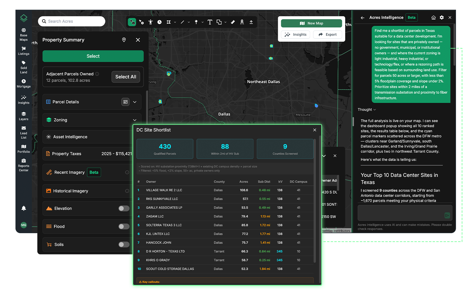
Rather than navigating separate GIS portals, county assessor records, and utility service territory maps, Acres brings parcel boundaries, ownership data, zoning context, infrastructure proximity, and transaction history into a single platform, so development teams can run the real infrastructure screen before investing due diligence resources in a site that will ultimately fail.
How Acres Supports Data Center Site Qualification
Acres gives data center development teams access to the most extensive, complete view of land data in a single system—parcel boundaries, ownership records, zoning classifications, environmental signals, and infrastructure context—for over 150 million U.S. parcels. For site selection teams screening secondary and tertiary markets for data-center-ready land, the platform surfaces infrastructure proximity signals that enable a power-first screen before formal utility engagement begins. See a complete, connected view of ownership, risk, and opportunity, instantly. Explore data center site analysis on Acres.
Weeks of land research become minutes with complete land data. The site readiness gap closes when development teams have better data at the screening stage, before capital is committed, before utility engagement begins, and before the site is in competition. For teams evaluating parcel-level infrastructure proximity and risk context across a wide geography, Acres provides the starting point that determines which sites are worth pursuing.
The Site Readiness Gap Is a Data Problem
Most land marketed as data-center-ready does not pass the real infrastructure tests that determine whether a site can deliver power on a viable timeline, clear permitting without unresolved risk, and support the cooling and scale requirements of modern workloads. The gap between marketing and diligence is where failed projects often originate.
Development teams that close this gap faster are the ones running infrastructure proximity analysis at the parcel level before committing due diligence resources. Power availability, substation proximity, zoning trajectory, permitting risk, and water access are all determinable before a site visit - and all determinable with the right data at the right stage of the deal cycle.
Ready to screen candidate sites faster? Explore parcel-level infrastructure context, zoning, and ownership data for millions of U.S. parcels on Acres. Book a demo to see how your team can conduct faster data center site analysis on Acres.
-Jul-21-2026-04-19-32-5320-PM.png)