GIS & Mapping
Map Highlight: U.S. Transmission Lines Map
Explore U.S. transmission lines and see how they affect land use and value. Visualize infrastructure with Acres’ powerful mapping platform.
Learn how to read property values on a map effectively, understand key factors influencing land value, and make informed decisions with Acres.com.

Land value is not uniform. Not across a county, not across a township, and not across a single road. Two parcels sitting side by side can carry dramatically different values depending on soil type, road access, flood risk, zoning designation, and what's sold nearby. If you're trying to figure out how to read property values on a map, the goal isn't just to find a number. It's to understand why that number exists, and whether it reflects the land's actual potential.
Acres.com brings together ownership records, parcel data, comparable sales, and land value layers for over 150 million parcels, so you can value land with confidence.
Why Reading Land Values on a Map Is Harder Than It Looks
How to Read Property Values on a Map: A Step-by-Step Guide
How Acres Approaches Land Value Mapping
Many people searching for land value head straight to a county assessor site or a generic property search tool and are met with outdated data and overwhelming interfaces. Assessed values lag the market, sometimes by years, and rarely account for recent sales activity, infrastructure changes, or land use shifts.
The result is that buyers overpay, sellers underprice, and landowners make capital decisions based on outdated information. Knowing how to find land value of a property, real market value rather than tax records, requires understanding what factors drive value in a specific location, and how to layer that data spatially on a map.
Land value mapping is a spatial skill. Values cluster, shift by boundary, and respond to the physical and legal attributes of each parcel. The steps below walk through how to approach a land value map systematically, whether you're a first-time buyer trying to understand what your land is worth, or a professional running a formal land valuation.
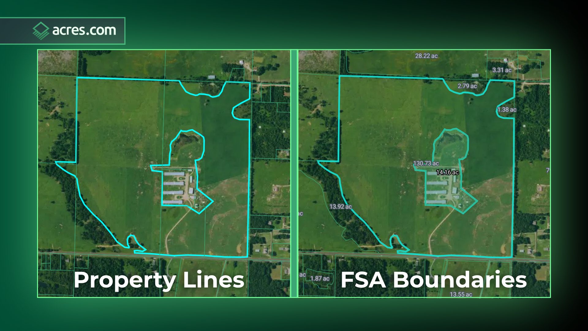
Before looking at any value figure, orient yourself to the parcel boundaries. A parcel is the legal unit of ownership, the shape that defines where one piece of property ends and another begins. On any land value map, parcel boundaries are the foundation.
Pull up parcel data for the address or area you're researching. Confirm the parcel's acreage, legal description, and owner of record. Values are tied to a specific parcel, not an approximate area.
Acres Tip:
Analyze both property lines and FSA boundaries for free, nationwide.
The most reliable way to determine land value is through comparable sales, recent transactions for similar parcels in the same market. A land value estimator or land appraisal calculator can generate a number, but comparables are what underwrite that estimate.
Look for sales within the past 12 to 24 months, within a similar distance from roads and utilities, and with comparable zoning and acreage. Sales from too far back or too far away introduce noise into your read.
When reviewing comparables on a map, look for price-per-acre trends across the visible transactions. If comparable sales cluster in a range and the parcel you're evaluating sits inside that cluster, you have a defensible baseline for land valuation.
Acres Tip:
Get the most complete and up-to-date view of land transactions across the U.S., including hard-to-access data from non-disclosure states.
.png?width=1920&height=1080&name=Comparable%20Sales%20Blog%20Image%201920%20x%201080%20(1).png)
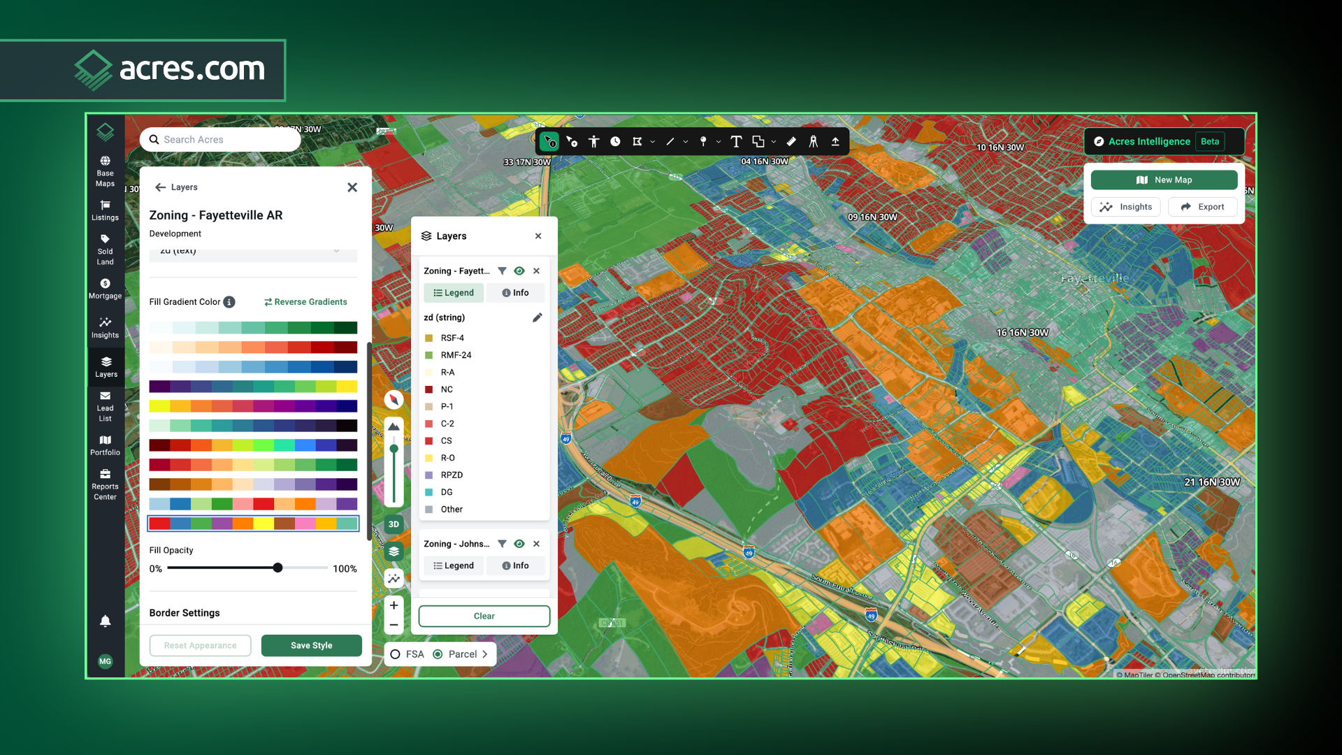
Zoning is one of the single largest drivers of land value, and it's invisible until you map it. A parcel zoned for agricultural use and a parcel zoned for commercial use can sit 500 feet apart and differ significantly in value. Cross-reference the parcel with its current zoning designation. Look for:
Land values by zip code often obscure zoning variation because they average across designations. Parcel-level zoning data eliminates that ambiguity.
Acres Tip:
Search thousands of data layers to surface easements and zoning classifications, or use Acres Intelligence to discover rezoning timelines, setbacks, and more.
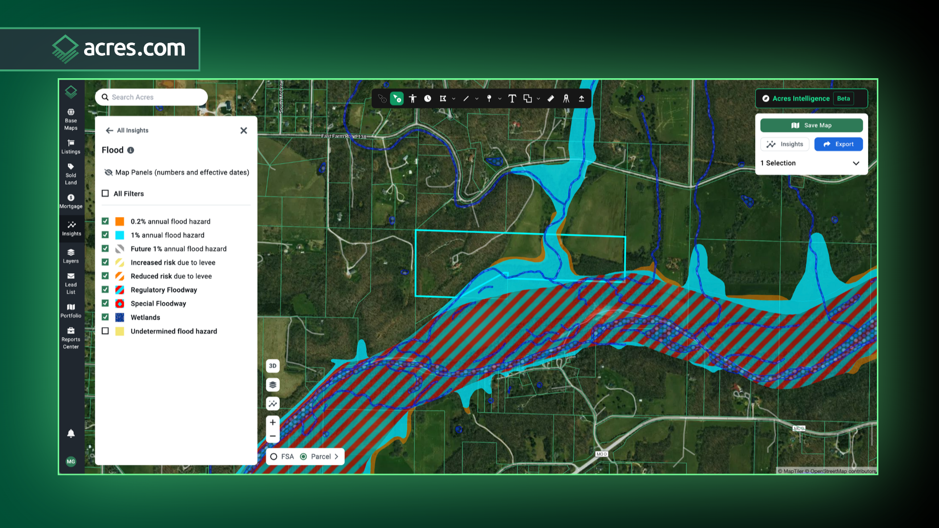
Flood zones, wetlands, and environmental constraints reduce land value, sometimes significantly. A parcel inside a FEMA 100-year flood zone can face higher insurance costs, restricted financing options, and reduced development potential. These factors don't always appear in an assessed value, but they show up in market behavior.
On a land value map, environmental overlays reveal which portions of a parcel are constrained and which are buildable. For irregular or large parcels, the constrained acreage can represent a significant share of total area. The effective usable acreage can be very different from the recorded legal acreage.
Run flood and wetland layers before finalizing any land value estimate. The difference between constrained and unconstrained acreage is often the difference between a fair price and an overpayment.
Acres Tip:
Overlay parcel insights like flood zones and environmental risk directly onto the map.
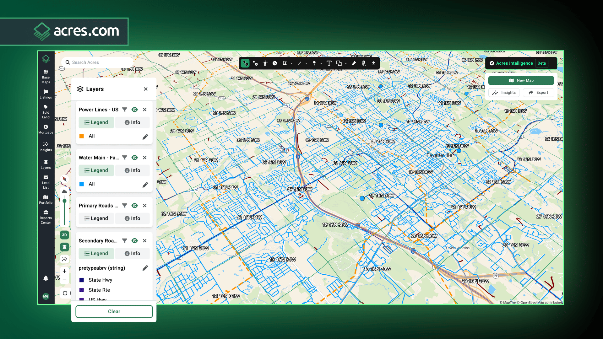
Road frontage, utility access, and proximity to infrastructure are value drivers that don't appear in a basic land record. A landlocked parcel with no legal easement to a public road is worth substantially less than an adjacent parcel with direct frontage, even at the same acreage and zoning.
On a value map, infrastructure proximity layers show where roads, power lines, water mains, and rail corridors sit relative to each parcel. These layers help explain why two adjacent parcels can carry different values even when acreage, zoning, and sales history look identical.
Acres Tip:
Use the infrastructure and road access layers in Acres to see frontage distance, utility proximity, and easement data without pulling a separate title report for each parcel you're evaluating.
Land value calculators and land values by zip code tools are useful starting points. A land price calculator or land worth calculator can give you a rapid ballpark, especially for markets you're less familiar with.
But treat those outputs as a first draft, not a final answer. A land value estimator aggregates data. It doesn't read the individual parcel. The steps above are how you verify whether the estimate holds up against the actual attributes of the specific property.
If the automated estimate diverges significantly from what the comparables and layers show, trust the primary data. The estimate reflects the average. The map reflects reality.
Running land valuation through a single, connected platform means the comparable sales, zoning overlays, infrastructure layers, and parcel records all reference the same geography, so your read is consistent, not stitched together from four different tools.
The challenge with reading property values on a map has always been data fragmentation. Comparable sales live in one system, zoning in another, flood data in a third. The time spent pulling those layers together often exceeds the time spent actually analyzing the parcel.
Acres brings ownership, comparables, zoning, environmental risk, values, and infrastructure data into a single parcel view for over 150 million parcels nationwide. When you search a parcel on Acres, you're not starting a research project. You're already looking at the complete picture. That's what makes land valuation faster and more defensible, whether you're a first-time buyer asking 'what is my land worth?' or a land team qualifying 40 parcels in a week.
That's the difference between stitching together a picture from multiple tools and starting with a complete one.
Reading property values on a map is a layered process. Start with the parcel boundary, anchor to real comparable sales, cross-reference zoning and environmental constraints, and verify infrastructure access before drawing any conclusions. Assessed values are a starting point, not a final answer, and land value estimators are useful benchmarks, not substitutes for parcel-level analysis.
The most important skill in land value mapping is knowing what drives value in a specific geography, and then layering that data spatially on the parcel you're evaluating. When those layers align, you get a read that holds up.
Ready to start reading land values on a map? Explore parcels, run comparable sales, and layer on zoning and risk data for any property in the U.S. at Acres.com.

Explore U.S. transmission lines and see how they affect land use and value. Visualize infrastructure with Acres’ powerful mapping platform.
Discover how substation locations influence land value, investment potential, and development. Explore the Acres Substations Map for data-driven...
Explore U.S. ethanol plants with Acres’ map. Learn how these facilities can influence land values, crop prices, and development.
