GIS & Mapping
Map Highlight: Sub-Surface Mineral Rights Map
See how Acres can help you discover sub-surface mineral rights’ impact on land ownership, property value, and resource management.
Explore 400,000 acres of government land that may hit the market. View the Federally Owned Lands Map free on Acres.com.

In a joint effort, the Department of Housing and Urban Development (HUD) and the Department of the Interior (DOI) plan to unlock around 400,000 acres of federally owned land. The goal? Tackle the affordable housing shortage by increasing the supply of buildable land.
The federal government is preparing to sell and repurpose underutilized land—including to developers. Now, you can see all that land in one place with the Federally Owned Lands Map on Acres.com.
The Federally Owned Lands Map, found in Acres’ Layer Library, is a free, interactive tool that gives you nationwide visibility into public land ownership. With this map, you can easily view:
All in one easy-to-use interface.
Connect with our sales team today to explore hundreds of data layers!
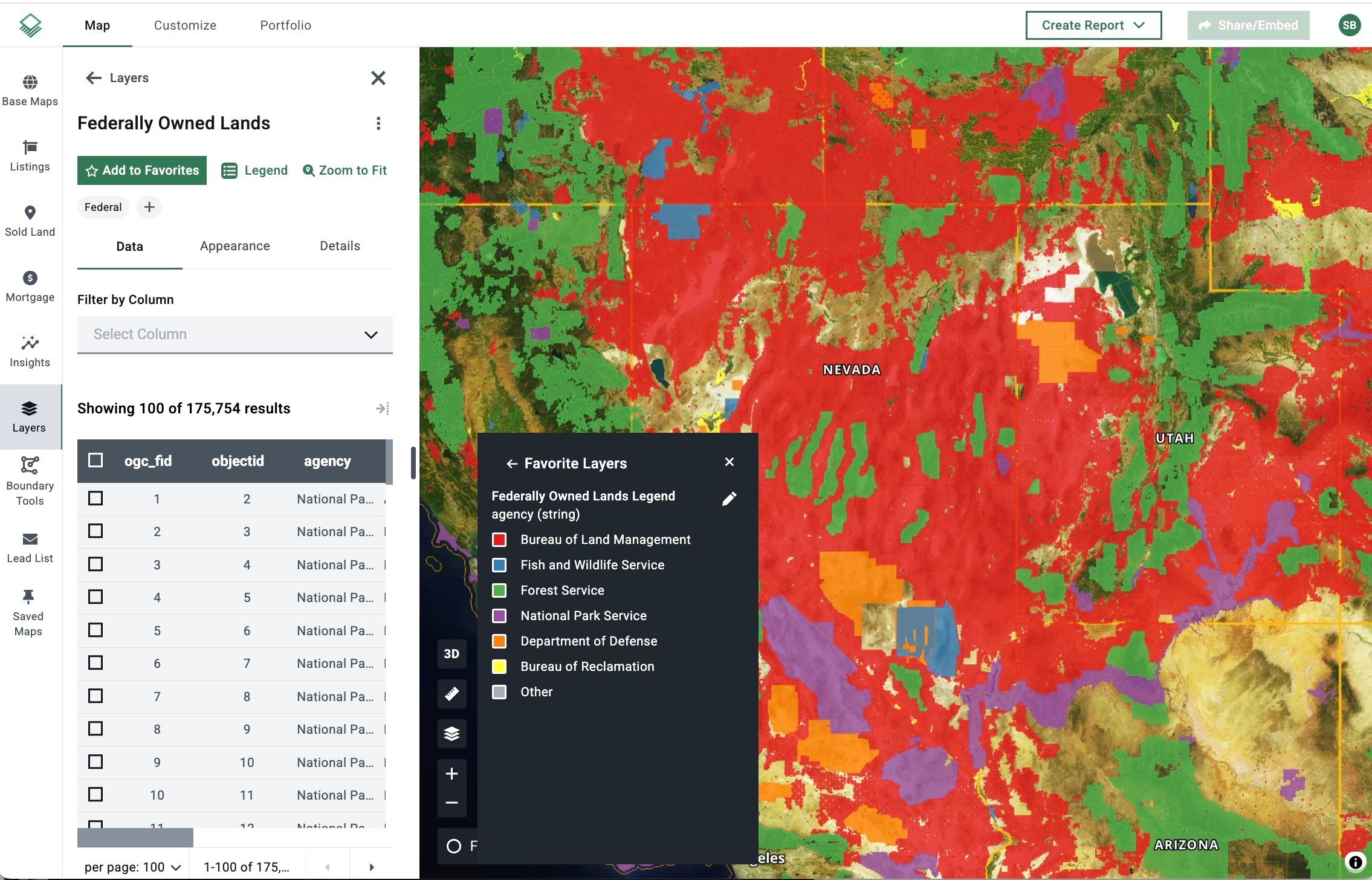
Acres’ federally owned land data is derived from Esri.
Use the Federally Owned Land layer to locate opportunities that align with HUD and DOI goals. Filter by location, access, and surrounding infrastructure to find parcels ready for residential development.
Clear property data matters. Acres aggregates ownership and boundary information into one platform—reducing guesswork and legal risk.
With a user-friendly interface and powerful data overlays, Acres simplifies land evaluation. Make smarter, faster decisions that align with evolving federal initiatives.
Custom, shareable maps make it easy to communicate opportunities with clients, team members, or partners. Users can highlight potential sites and generate professional reports with just a few clicks.
Acres updates its land data, sales, and mapping layers in real-time. When federal assets hit the market, users are among the first to know—keeping them ahead of the competition.
With the possibility of government land sales, Acres’ free Federally Owned Lands Map can help you plan your next move. Whether you’re a buyer, seller, investor, or land manager, this tool provides the insights you need to act confidently and stay ahead of the market.
See how Acres can help you discover sub-surface mineral rights’ impact on land ownership, property value, and resource management.
Explore the USDA organic map on Acres and locate certified operations across the U.S. to discover market opportunities and land value insights.
Discover who owns U.S. farmland. Explore Acres’ visualization of foreign-owned agricultural land by county and uncover key trends in ownership.
