A list of land listings looks like a spreadsheet. Acres, prices, and county names stacked in rows. Useful for sorting, but not for understanding. When you switch to a map view, the picture changes entirely. Property lines appear. Neighboring ownership comes into focus. Road access, flood zones, and development patterns reveal themselves in a single glance. Searching for land online with a map-first approach is a fundamentally different way to evaluate what you are looking at.
Acres.com is built around this principle. Every search starts with the geography, so buyers, brokers, and developers get the full spatial context before they ever open a parcel record.
The Limitations of Spreadsheet-Based Land Market Searches
Most land searches start the same way: a buyer types a county name or price range into a listings platform and scrolls through rows of results. The problem is that land is a physical asset bound by location dynamics, topography, and surrounding infrastructure. None of that shows up in a list.
Buyers relying on list-only searches regularly miss the factors that matter most. A parcel map search reveals that a promising lot is landlocked, sitting behind three private parcels with no road access recorded. Another shows that a county line runs directly through the middle of the acreage. A third reveals that the parcel next door sold for 30% less six months ago.
The parcel map search is not just a nice-to-have, but the tool that turns an online land search from a guesswork into a data-backed research process.
What a Map View Shows That a List Cannot
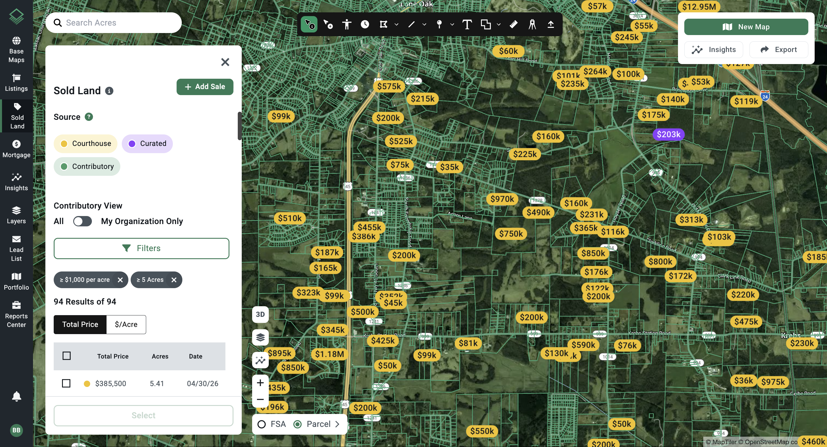
When you open an interactive land map and navigate to a target area, you immediately see information that a list view cannot surface. Property boundaries define the exact footprint of each parcel. Neighboring ownership data shows who controls the land on all sides—critical for evaluating access, future development patterns, and potential consolidation opportunities.
Zoning overlays reveal what the land is actually permitted for, not just what a seller claims it could be. Flood zone layers surface FEMA designations before you invest any research time on a parcel that carries significant environmental risk. Road and infrastructure proximity data answers the question buyers and developers ask first: can you get to it, and can you build on it?
Each of these data layers are visible in seconds on a parcel boundary map. In a list view, they are not visible at all.
How Map View Accelerates the Shortlist Process
Land buyers spend very little time on parcels that do not meet their criteria. The map view makes this possible. Rather than clicking into each listing to find that the lot has no road access or sits in a 100-year flood zone, a buyer can filter by visual geography and eliminate poor candidates in the first pass.
The process works like this: start with a target geography on the land ownership map online, define a rough search area, then zoom in on clusters that match the size and zoning requirements. Tap a parcel boundary to surface ownership details, last sale date, and assessed value. If the parcel qualifies at a first glance, it moves to the research list. If it does not, move on immediately.
This is not a shortcut. It is a faster version of the same due diligence that front-loads the spatial reality check rather than discovering deal-killers after hours of research.
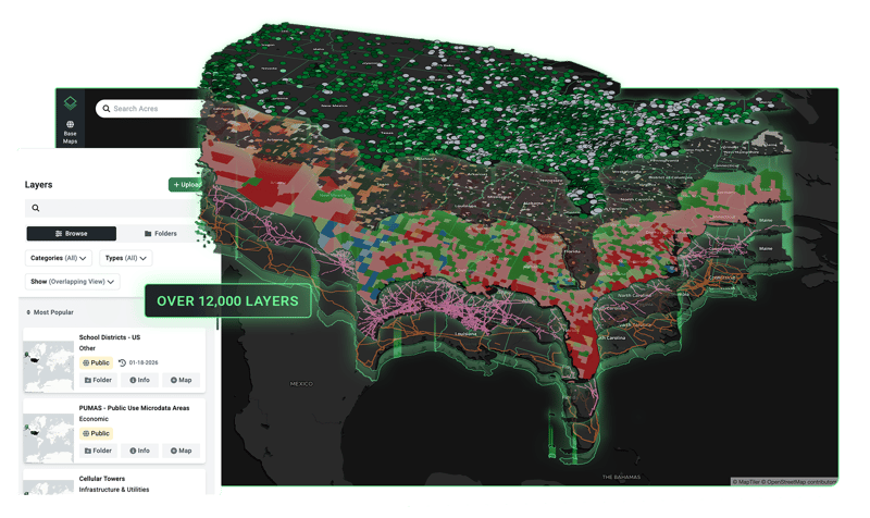
With Acres: Search land by map using Acres' interactive parcel search, which covers over 150 million parcels nationwide. Pan and zoom to any geography, tap parcels to surface ownership, sale history, and parcel context, and toggle data layers including zoning, flood zones, and infrastructure proximity—without leaving the map view.
Reading Market Context from the Map
A land parcel viewer does more than show individual lots. It makes market patterns visible. When you see a cluster of recently sold parcels in one section of a county, that is a signal. When permit activity is concentrated along a particular corridor, that tells you something about where development momentum is building. When large contiguous blocks of land show the same owner, that points toward consolidation risk or a potential off-market conversation.
None of these patterns appear in a list. They only emerge when you look at the geography as a whole. Online land search tools that default to a map view give buyers and brokers a market intelligence advantage that list-first platforms cannot replicate.
The Difference Between a Parcel Viewer and a Land Search Platform
County assessor parcel viewers exist in most jurisdictions. They show boundaries and basic ownership data, but they are built for tax administration, not land research. They rarely include sale history, zoning overlays, environmental flags, or infrastructure context. Navigating between multiple county viewers to cover a multi-county search area costs real time.
A purpose-built land search map view brings all of this data together. Rather than pulling records from separate county sources and cross-referencing them manually, buyers can access standardized, up-to-date parcel data across geographies in a single interface. The time savings are significant. More importantly, the consistency of the data means fewer surprises when due diligence begins.
The underlying principle is simple: land is spatial, and land research should be spatial from the start. Buyers who begin their online land searches with a map view consistently reach confident decisions faster than those who start with lists.
Rather than piecing together parcel data from separate county sources, Acres brings ownership, zoning, transaction history, and environmental signals into one map-first platform, so the picture is complete before the first offer is considered.

How Acres Puts the Map at the Center of Every Search
Acres is built on the principle that land research should be transparent and complete. The platform puts boundaries, ownership data, and parcel context front and center for every search, so buyers work with full transparency from the first click.
Map parcels nationwide, surface records, and layer in additional data like zoning, infrastructure proximity, flood risk, and more—without switching platforms.
For teams running multi-county searches or tracking large acquisition pipelines, the map view makes it possible to see the whole picture at once.
Start With the Map
When you are searching for land online, the map view is not just a display preference. It’s a complete land research tool. Property boundaries, ownership patterns, zoning overlays, and environmental signals all become visible the moment you switch from a list to a map.
Buyers who use a map-first approach eliminate poor candidates faster, surface market context earlier, and reach due diligence with a shorter, better-qualified research list.
The next time you start a land search, open the map first. The information you need to qualify or disqualify a parcel is right there.
Ready to eliminate manual data aggregation from your acquisition workflow? Request a demo to see how your team can centralize parcel boundaries, ownership data, and environmental layers into a single, map-first interface.