Data Centers
6 Key Takeaways: Turning Land and Utility Data into Deal Flow
Learn how to leverage land data to streamline the process of finding and valuing power-ready land with Acres’ Rush Evans.
The future grid is built on land data. Discover how complete land research helps utilities find powered land, fix bottlenecks, and reduce risk.

The biggest bottleneck to building renewable energy, expanding the grid, or serving data center demand isn’t funding or technology—it’s land, specifically land that’s powered, permitted, and infrastructure-ready. What’s changing now is the central role land plays in nearly every major planning decision utilities make.
No longer just the site where infrastructure happens to sit, land has become a scarce and competitive asset shaped by capacity constraints, environmental complexity, and accelerating developer activity. Understanding these factors early is emerging as a critical advantage for utilities looking to plan proactively and de-risk projects.
A Broken Land Data Model Leads to Costly Mistakes
For decades, location drove land decisions. Today, capacity does. Developers, hyperscalers, and energy companies may make land moves years before utilities have reliable information about grid headroom or substation availability.
Too often, utilities are left reacting to choices others already made—sometimes on parcels that appear promising but lack actual capacity. Much of the data needed to evaluate powered land either isn’t public, isn’t current, or simply isn’t structured for rapid decision-making. As a result, they struggle to differentiate between land with real grid potential and land that only looks viable on paper.

There are thousands of gigawatts worth of projects stuck in U.S. interconnection queues and average wait times span 5–10 years. It’s increasingly difficult for utilities to plan confidently when they can’t ensure grid access.
“Phantom projects” delay timelines and make it nearly impossible for utilities to proactively align land strategy with actual system needs. Meanwhile, high-demand regions are unable to build quickly enough to meet load growth.
Most utilities are hampered by data fragmentation and can’t easily see hosting capacity below the substation level.
This forces engineers to spend hours evaluating parcels that never had capacity to begin with, making siting reactive instead of strategic. In a world where siting decisions are increasingly complex, centralized land data is critical for de-risking projects and making confident decisions.
Habitat designations, wetland boundaries, conservation restrictions, and environmental constraints can surface late in a project’s lifecycle, derailing plans that look feasible on paper. These surprises can cause permitting delays, regulatory uncertainty, and complicate long-term planning.
You need ways to understand environmental risk at the parcel level before committing resources—not after studies expose conflicts.
Assembling linear corridors or contiguous parcels is slow and expensive. Terrain, land use conflicts, environmental constraints, and political concerns all influence route feasibility—yet most utilities still lack tools that assess or compare corridors at a systems level. Without centralized land data, it’s nearly impossible to identify viable transmission pathways, understand their tradeoffs, or model environmental friction ahead of time.
.jpeg?width=5570&height=3714&name=AdobeStock_443702444%20(1).jpeg)
Across all of these challenges, a common thread emerges: utilities are forced to make high-stakes decisions using fragmented information. Land acquisition teams, environmental planners, engineers, and external partners often work from different versions of the truth.
The result is costly misalignment: overpaying for parcels without clear capacity, missing early warning signs that derail permitting, or relying on spreadsheets and PDFs to guide billion-dollar siting decisions. The status quo is unsustainable for the pace the grid now requires.
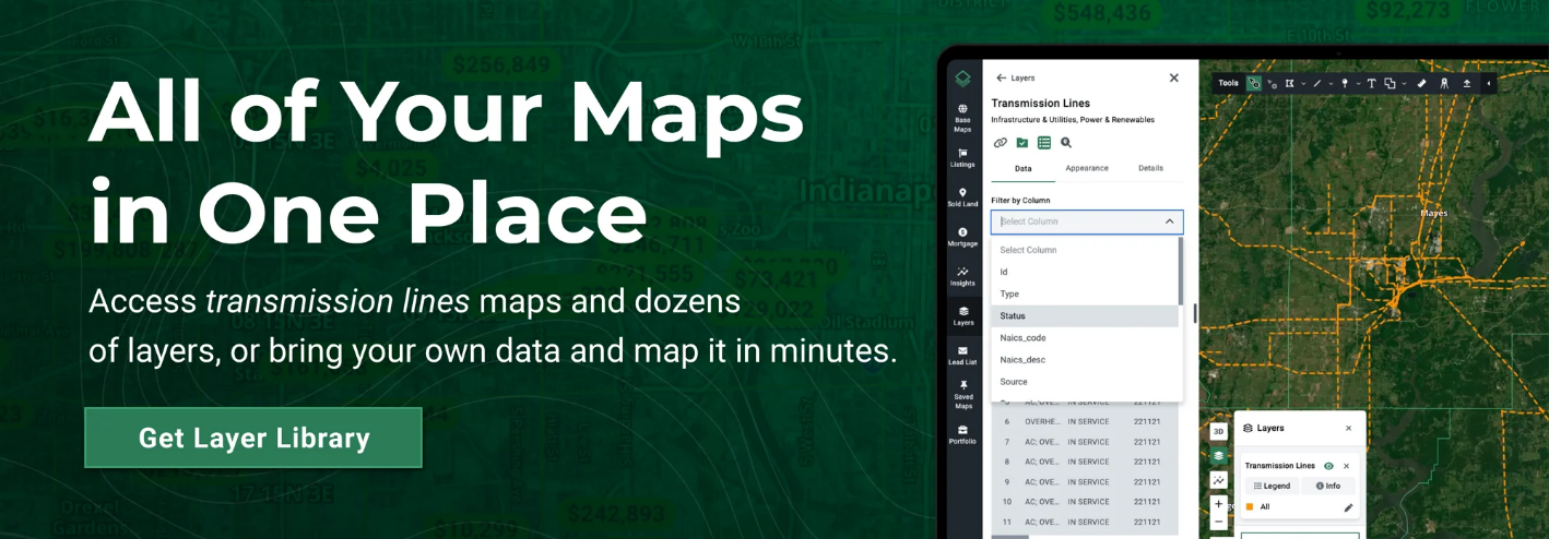
To shift from reactive land buying to strategic land planning, you need a complete land research platform. By combining parcel-level ownership details with zoning, environmental overlays, grid proximity, and more, Acres enables you to see the full picture instantly, and with the full context needed for long-term planning.
Eliminate data silos and tool hopping with 4,000+ data layers including zoning, infrastructure, environmental risk, and more.
Identify powered land instantly by visualizing high-capacity lines and proximity to existing infrastructure.
Pre-score parcels for risk and feasibility to quickly rule out unsuitable parcels before permitting surprises or late-stage conflicts derail timelines.
With clearer visibility into powered land, environmental risk, and off-market opportunities, you can make decisions that align long-term planning with real feasibility. Land data doesn’t just reduce friction—it unlocks the ability to plan proactively, collaborate more effectively, and move with the speed of today's energy demands.
Trams that utilize this capability now will be better positioned to meet rising load needs and serve emerging demand with confidence. If you’re ready to explore how a more integrated approach to land, grid, and environmental data can streamline planning and reduce uncertainty, connect with our team today.
Learn how to leverage land data to streamline the process of finding and valuing power-ready land with Acres’ Rush Evans.
Land markets are shifting—and with disruption comes opportunity. Here’s how smart land buyers can use Acres to navigate uncertainty.
Don't wait for listings. See how Acres’ complete land research tools help you find off-market deals before others do.
