GIS & Mapping
Map Highlight: Chicago, IL Zoning Map
Explore the interactive Chicago zoning map on Acres. Access accurate, parcel-level zoning data for smarter land investment, planning, and development.
Understand how an AI zoning analysis tool like Acres gives land professionals instant access to parcel zoning data across 150M+ parcels nationwide.
Every development land deal starts with one question: what can actually be built here? Zoning determines the answer. Yet finding that answer has always been harder than it should be. County websites go down, code books contradict each other, and a parcel that looks perfect on a map can hide overlapping overlays or outdated classifications that can kill a deal weeks in.
Acres.com has zoning data across more than 150 million parcels in a single platform, so your team can get answers in seconds instead of days.
Why Zoning Research Still Slows Land Teams Down
What Zoning Intelligence Actually Means
How Acres Intelligence Decodes Zoning Across Nationwide Jurisdictions
The Problem With DIY Zoning Lookups
What a Zoning Intelligence Platform Does That a Map Cannot
How Acres Intelligence Handles Zoning Data
The Bottom Line on Zoning Intelligence
The United States has more than 30,000 local zoning jurisdictions, each with its own codes, naming conventions, overlay districts, and update schedules. A code labeled R-2 in one county may mean something entirely different in a neighboring one. Parcel zoning data is rarely housed in a single place, and many county GIS portals lag months or years behind current designations.
For land professionals, this fragmentation carries real cost. When you need to know how to find zoning for a property, the process often means cross-referencing county GIS tools, calling a planning department, and still not being certain the data reflects a recent reclassification. That delay costs time, capital, and, in competitive markets, the deal itself.
Zoning intelligence is not simply a property zoning map you can pan and zoom. It is the ability to retrieve, interpret, and act on zoning designations at the parcel level, in context, at scale. It means knowing not just what zone a parcel sits in, but what that zone permits, what overlays apply, and how that classification interacts with adjacent land use patterns.
Traditional zoning research requires assembling that picture from multiple sources: a land zoning map from the county, a separate overlay district layer from a state portal, and a call to confirm whether a recent rezoning has been entered into the system yet. A true zoning intelligence platform collapses that process into a single view.
Building a reliable zoning dataset means solving a problem that has stumped the industry for decades: local zoning codes lack a unified data structure.
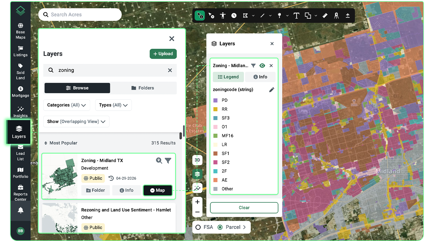
Acres has robust datasets that map local code designations to help teams understand use categories, so a land professional searching across multiple counties sees consistent, comparable zoning classifications regardless of how each jurisdiction labels its codes.With Acres, teams can screen parcels by permitted use category across multiple jurisdictions simultaneously, making cross-market comparison fast and reliable, identify opportunities that match their acquisition criteria, and move to outreach faster.
When land professionals need to check the zoning of a property, the default approach is a patchwork of county GIS portals, state mapping tools, and planning department calls. Each source has gaps. County portals may not reflect recent rezonings. State parcel datasets vary widely in update frequency. Phone calls depend on staff availability and institutional knowledge.
A zoning code lookup AI approach changes the process of due diligence research entirely. Rather than spending hours confirming parcel designations, teams can run zoning checks across hundreds of parcels in a single session.
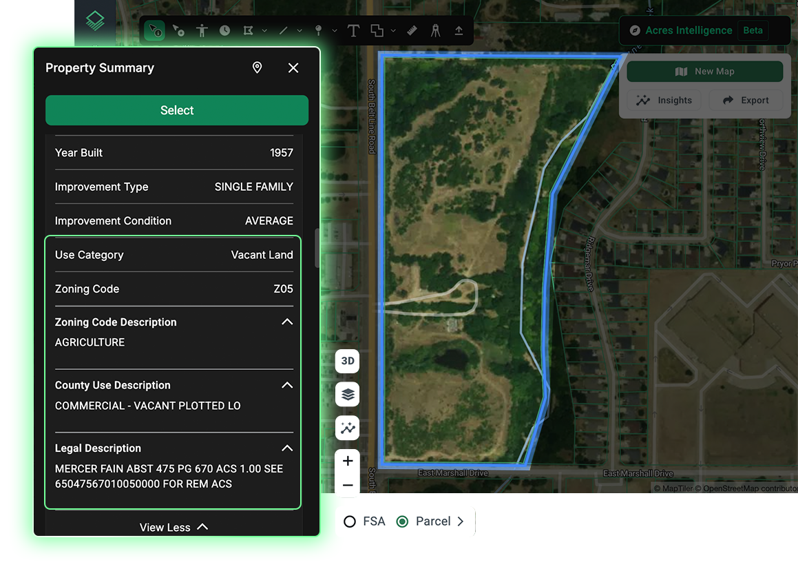
Acres consolidates property ownership, transaction history, zoning, environmental risk, and infrastructure context into one view. Rather than piecing together zoning data from multiple county portals and planning department calls, teams get the full picture from a single platform. That is how weeks of zoning research can become minutes.
A standard property zoning map or land zoning map shows you where zones are drawn. A zoning intelligence platform tells you what those zones mean for your specific deal. There is a meaningful difference.
A zoning map by address can confirm that a parcel is zoned A-1. But it takes a zoning intelligence layer to surface that the parcel also sits within a conservation overlay, that the adjacent parcel was recently rezoned to R-3, and that the county's current comprehensive plan calls for future commercial expansion along that corridor. Each of those signals matters for deal underwriting.
The value is not just speed. It is the reduction in uncertainty that comes from having clear, layered data rather than scattered, inconsistent records. For teams running prospecting at scale, a property zone lookup that covers entire counties or states at once is the difference between a manageable pipeline and an overwhelming one.
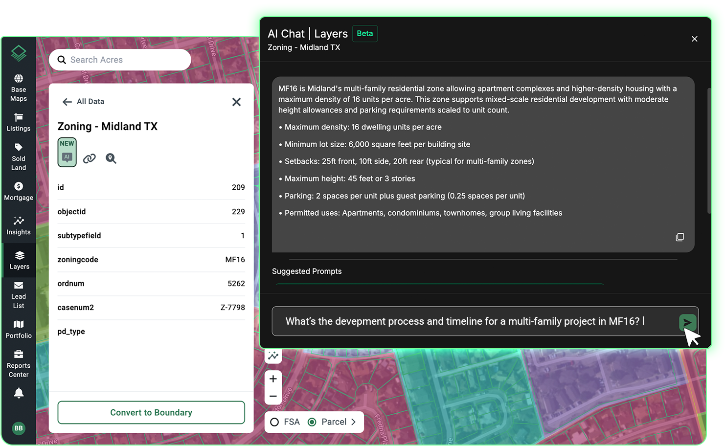
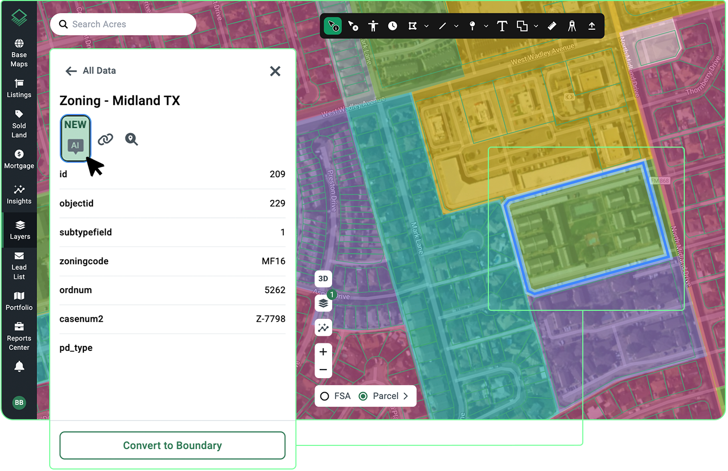
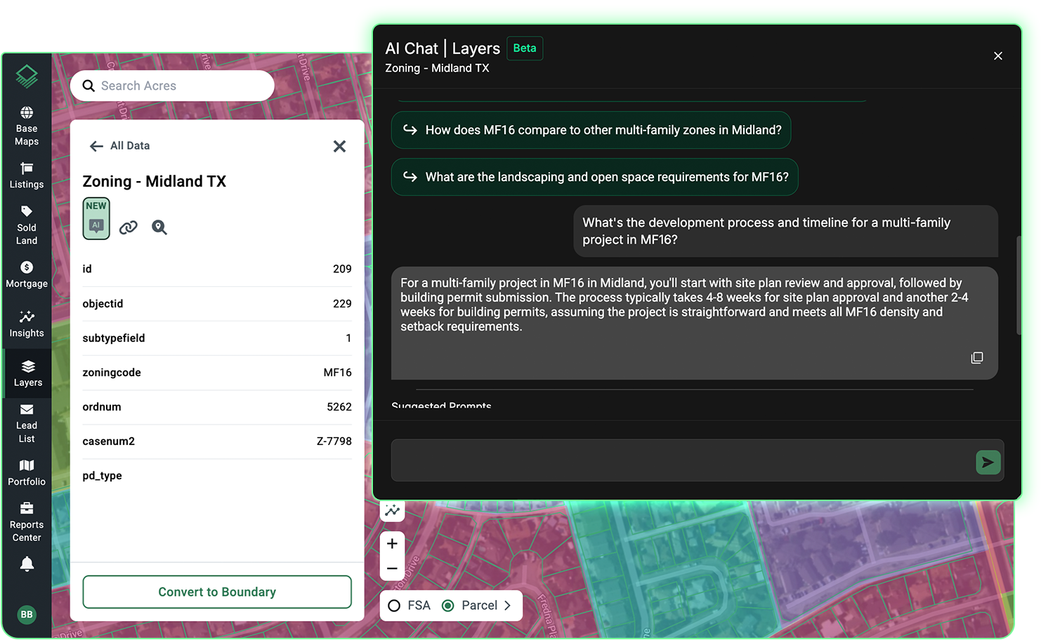
When you pull up any parcel, Acres Intelligence surfaces the current zoning designation, the standardized use category, and applicable overlays, without requiring a separate search or a visit to a county portal. The platform draws on the most recent, relevant land data available, refreshed continuously across thousands of datasets.
Using Acres’ AI zoning chat agent, teams can get instant clarity on setbacks, timelines, potential land use changes, and more.
Here’s how:

For teams doing multi-market site searches, Acres makes it possible to identify parcels that match permitted use criteria, and layer in ownership, risk, and infrastructure data, all from the same view in just minutes.
If your team can describe what they are looking for, they can find it.
The United States will continue to have thousands of local jurisdictions, each maintaining its own codes on its own timeline. The teams that move fastest are the ones who have adopted a standardized research approach rather than fighting through it deal by deal.
A powerful AI zoning analysis tool gives land professionals reliable parcel zoning data across every market, in a single view, without the manual assembly that slows traditional due diligence. The next time your team needs to find zoning by address or assess a property's permitted use across a regional portfolio, the answer should take seconds, not days.
Ready to run accurate zoning diligence for your markets in just minutes?
Connect with our team to see how exploring nationwide zoning data in just minutes becomes a possibility with Acres.

Explore the interactive Chicago zoning map on Acres. Access accurate, parcel-level zoning data for smarter land investment, planning, and development.
Discover zoning codes and overlays with Acres’ Columbus Ohio zoning map. Get parcel-level insights and evaluate land potential with confidence.
Explore Miami’s zoning map and learn how the Miami 21 code shapes sustainable, mixed-use development. Access parcel-level zoning data with Acres.
