Land price per acre varies more than most buyers expect. A single county can hold parcels priced at $1,000 per acre and others priced at $15,000 per acre, separated by nothing more than a road and a zoning line. Before you make an offer, build a list of comparable sales, or even shortlist a deal, you need to know how to read the market you are entering.
Acres.com brings parcel-level ownership data, transaction history, zoning context, and infrastructure layers together so you can research land value per acre without piecing together a dozen sources manually.
Contents
Why Researching Land Prices Is Harder Than It Looks
How to Research Land Prices in Any Market in 5 Steps
How Acres.com Supports Land Price Research
Researching Land Price Per Acre: What to Remember
Why Researching Land Prices Is Harder Than It Looks
Unlike residential real estate, land markets have no universal pricing index. There is no Zillow-equivalent for raw acreage that reliably tracks per-acre values across markets. USDA data shows average farmland values in the U.S. reached $4,170 per acre in 2024, but county-level variation within a single state can be dramatic, making national or state averages poor proxies for deal-level decisions.
The challenge compounds because land price per acre is shaped by factors that do not show up in a basic MLS or tax record search: soil classification, flood zone status, water availability, zoning overlays, road access, and proximity to utilities. A buyer relying on surface-level data risks overpaying for constrained parcels or passing on undervalued ones because a key data layer was missing.
This guide walks you through a repeatable research framework for understanding land value per acre in any market, from identifying the right comps to reading the physical and regulatory factors that drive price.
How to Research Land Prices in Any Market
Step 1: Establish Your Market Boundary
Before you look at a single comparable sale, define the geographic scope of your research. Land markets are hyper-local. A 30-mile radius can span three distinct pricing tiers based on proximity to infrastructure, municipality boundaries, and county zoning rules.
Draw your search boundary around the subject parcel first. Use county lines, zip codes, or natural geographic breaks such as river corridors or highway interchanges as logical market edges. Tight boundaries produce cleaner comps. Loose boundaries introduce noise from markets that do not compete for the same buyer pool.
With Acres:
Use the map search to draw a custom boundary around your target area. Filter by parcel size, land use code, and transaction date to pull only the comps that reflect the same product type you are evaluating.
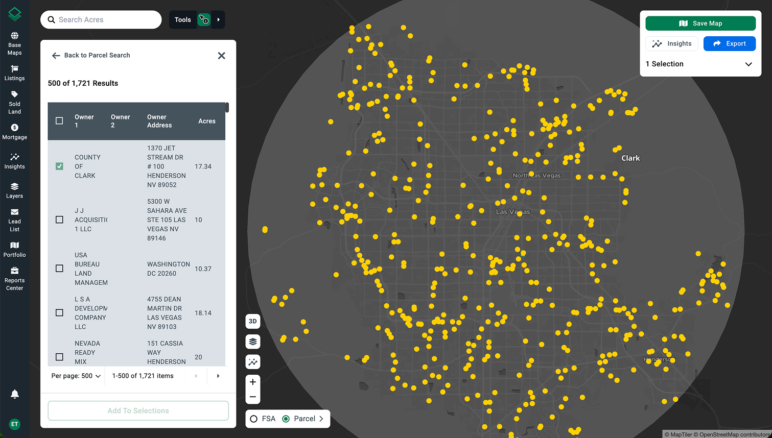
Acres.com parcel search results within a custom-drawn market boundary
Step 2: Pull Recent Sales Comps for Your Parcel Type
Relevant comparable sales share three characteristics with your subject parcel: similar acreage, similar land use or zoning classification, and a sale within the past 12 to 18 months. Sales older than two years are unreliable in most markets because interest rate shifts and development activity compress or expand land values quickly.
When learning how to find land comps, avoid mixing parcel types. Agricultural ground priced per acre on soil productivity is not comparable to a raw residential development site priced on net developable acreage after setbacks and easement deductions. Build separate comp sets for each use category and calculate a value per acre range for each.
USDA NASS tracks average farmland and cropland cash rents by state and region each year, which gives you a useful benchmark for agricultural ground. For development or transitional land, county assessor transaction records and deed transfers are the most reliable primary data source.
With Acres:
Find relevant comparable sales with quick filters for acreage, location, land use, or other key factors.
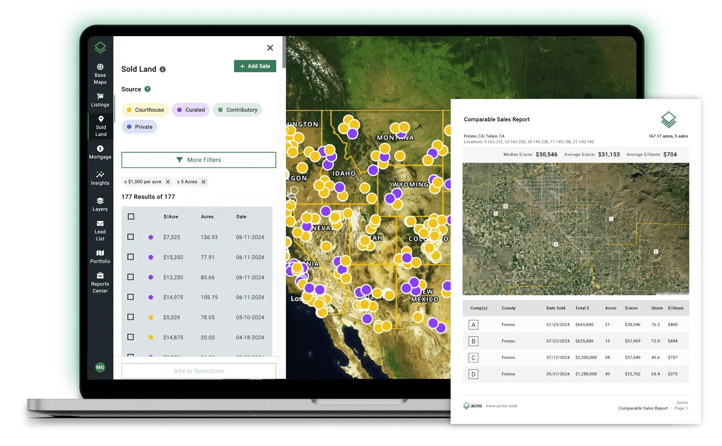
Acres.com sold land database and comparable sales report
Step 3: Identify the Factors Affecting Land Value in Your Target Area
Raw transaction data only tells you what buyers paid, not why. To understand land value per acre in a specific market, you need to account for the physical and regulatory variables that explain pricing differences across parcels.
Key factors affecting land value include:
- Zoning classification and permitted uses: What the land can be developed into drives ceiling value. Agricultural land with a residential zone overlay will trade at a premium over identical unzoned acreage.
- Soil quality and productivity: For agricultural parcels, USDA NRCS Soil Capability Class ratings directly correlate with per-acre value. Class I and II soils consistently command higher prices than Class IV and below.
- Flood zone designation: FEMA flood maps classify land into high, moderate, and minimal risk zones. High-risk flood zone parcels trade at a discount in most markets because development cost and insurance obligations increase materially.
- Infrastructure proximity: Water, sewer, electric, and road access all affect the cost to develop a parcel. Land that requires significant off-site infrastructure investment prices lower on a net-value basis than a comparable parcel that is shovel-ready.
- Population and demand trends: U.S. Census population growth data helps you identify markets where residential and commercial demand is accelerating, which typically compresses land supply and raises per-acre pricing for developable ground.
With Acres:
Surface all of these factors and more using thousands of data layers from Acres.
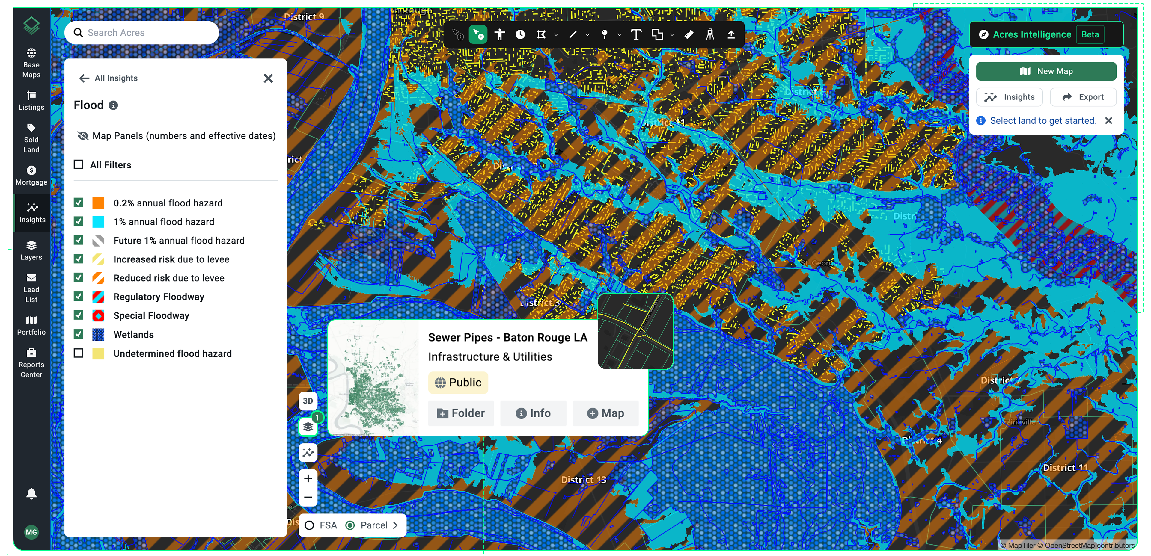
Acres.com flood zone and sewage infrastructure layers overlaid on a parcel map
Step 4: Adjust Your Comparable Values for Parcel-Specific Differences
A comp set gives you a price range, not a price. To arrive at a reliable land value per acre estimate for a specific parcel, adjust your comps upward or downward based on the physical and regulatory differences identified in Step 3.
Common upward adjustments: superior soil classification, no flood zone exposure, utility connections on-site, paved road frontage, favorable zoning with short entitlement timelines.
Common downward adjustments: floodplain encumbrance, easements that reduce net usable acreage, irregular parcel shape that limits development configuration, distance from public water and sewer, and prior environmental activity that requires investigation.
Document every adjustment and its basis. If you cannot quantify an adjustment from market evidence, note it as a qualitative risk factor rather than applying an unsupported dollar figure to your estimate.
Step 5: Cross-Check Your Estimate Against Land Price by State Benchmarks
Once you have a parcel-specific estimate, check it against regional and state-level benchmarks to confirm you are within a reasonable range. State-level data from USDA ERS and NASS can provide context for whether your per-acre value is consistent with the broader market or a significant outlier that warrants additional scrutiny.
How Acres.com Supports Land Price Research
Rather than toggling between USDA tables, county GIS portals, FEMA flood maps, and assessor databases for each parcel, Acres unifies the data layers that drive land valuation into a single system.
From the parcel map, you can access ownership history, zoning classifications, flood designations, soil productivity data, infrastructure proximity, comparable sales, and more. Land valuation tools on Acres let you filter by parcel type and layer in the physical and regulatory context that explains pricing differences across a market.
Weeks of land research becomes minutes.
Researching Land Price Per Acre: What to Remember
Reliable land price per acre research follows a sequence: define your market boundary, pull comps that match your parcel type, identify the physical and regulatory factors affecting land value in that area, adjust for parcel-specific differences, and cross-check against state or regional benchmarks.
No single data point gives you a complete picture.
The most common mistake buyers make is relying on average cost of land per acre figures without accounting for the local variables that explain why two parcels in the same county can trade at very different prices. Build your estimate from the bottom up, document your adjustments, and verify every data layer before you commit to a value.
Start Researching Land Values on the Acres Map
Explore parcel data, run comps, and access the ownership and regulatory layers that drive land value per acre in any market. Connect with our team to get started.