More than 900 million acres of agricultural land are privately held across the United States. Every acre exists as part of a defined unit that county governments, buyers, and land professionals rely on to describe, transfer, and research property. That unit is a land tract.
Whether you are evaluating rural land for sale, running a parcel search, or studying a land parcel map, understanding what land tracts are and how they work is the foundation for any smart land decision.
Acres.com gives you parcel-level data on over 150 million parcels nationwide so that every search starts with a complete picture.
Contents
What Is a Land Tract?
Why Land Tracts Are Harder to Research Than They Look
How Land Tracts Are Classified
How to Find Land Tracts
How Acres Handles Land Tract Research
Key Takeaways
What Is a Land Tract?
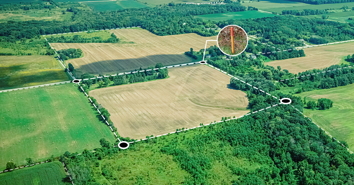
A land tract is a defined area of land with recorded legal boundaries. It is identified by a parcel number, legal description, or survey reference in county records. Land plots and land parcels are terms often used interchangeably with land tracts, though in practice the distinctions can matter depending on context.
In legal and government contexts, a parcel typically refers to the taxable unit recorded by a county assessor. A tract is a broader term that can describe any surveyed piece of land, including parcels that have been grouped together or a portion of a larger subdivision. A land plot most often describes an individual lot within a platted subdivision, where a surveyor has divided a larger tract into numbered pieces.
For practical land research purposes, the terms overlap significantly. What matters is that every land tract has:
- A unique identifier (parcel ID or APN)
- A legal description tied to survey data
- Recorded ownership in county files
- Boundary coordinates visible on a land parcel map
Why Land Tracts Are Harder to Research Than They Look
Land tracts do not always show up with neat labels on a standard map. County recording systems vary, legal descriptions differ by state, and parcel boundaries can shift over time through subdivision, consolidation, or survey corrections.
For buyers and land professionals, this creates a real problem: the data you need to evaluate a tract is often scattered across multiple government sources, paper records, and disconnected databases.
In many rural counties, farmland ownership turnover has increased in recent years. That means more land tracts are changing hands, new boundary configurations are being recorded, and the parcel data landscape is shifting faster than most research tools can track. Understanding exactly what a land tract is, how it is defined, and where reliable data lives is the first step to making faster, more confident land decisions.
How Land Tracts Are Classified
Land tracts are classified in a number of ways depending on the county, state, and intended use. Common classification types include:
- Agricultural tracts: farmland, timberland, and grazing land, typically recorded in large acreage blocks with USDA Farm Service Agency numbers assigned alongside county parcel IDs.
- Rural residential tracts: larger lots outside platted subdivisions, often described by metes and bounds or section-township-range references.
- Commercial and industrial tracts: land sites zoned for development, often with additional regulatory overlays from municipal or county planning departments.
- Conservation and government tracts: parcels held by federal or state agencies, land trusts, or conservation easements, which appear on county parcel maps but carry restricted-use designations.
How to Find Land Tracts
A land tract search has historically required piecing together data from county assessor portals, state GIS systems, and FEMA flood mapping tools. Many county assessor portals offer a basic parcel search by address or APN, but the data is rarely connected to ownership history, zoning context, or environmental overlays in a single view.
A more complete land tract search process looks like this:
Step 1: Start with a Parcel Search on Acres
Rather than pulling parcel boundaries from a county GIS portal, a USDA database, and a FEMA flood map separately, begin your land tract search on Acres. Acres brings ownership records, parcel boundaries, zoning data, and environmental risk layers into one place for over 150 million parcels nationwide. Search by address, APN, or draw a search area directly on the map.
With Acres: Use the map search to pull up any land parcel instantly. Filter by acreage, land use type, or ownership status without leaving the platform.
Step 2: Review Parcel Boundaries and Legal Description
Once you locate a tract, confirm its boundaries against the recorded legal description. Check for any splits, mergers, or recent survey amendments in the parcel history. Overlapping claims or boundary irregularities are common in rural counties and can affect title.
With Acres: Zoom into any parcel nationwide and see the parcel lines appear immediately.
Step 3: Check Ownership and Transaction History
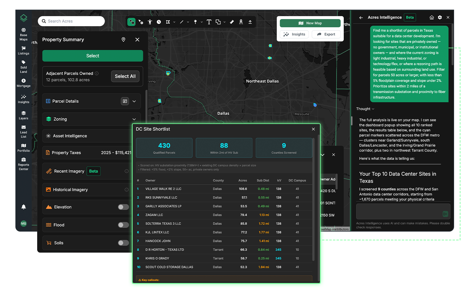
Land parcel ownership data tells you who holds the tract, how long they have held it, and what the most recent recorded transaction looked like. This context is essential for prospecting rural land for sale, identifying motivated sellers, or understanding market pricing in a specific area. Acres surfaces this data at the parcel level so you do not need to file a county records request for basic ownership information.
For teams sourcing acreage at scale, the ability to filter by ownership type, land plot size, and last-sale date across entire counties gives you a significant research advantage.
With Acres: Each parcel has ownership and transaction history data included. Use Acres Intelligence to dive deeper and unmask mortgages, portfolio holdings, and more.
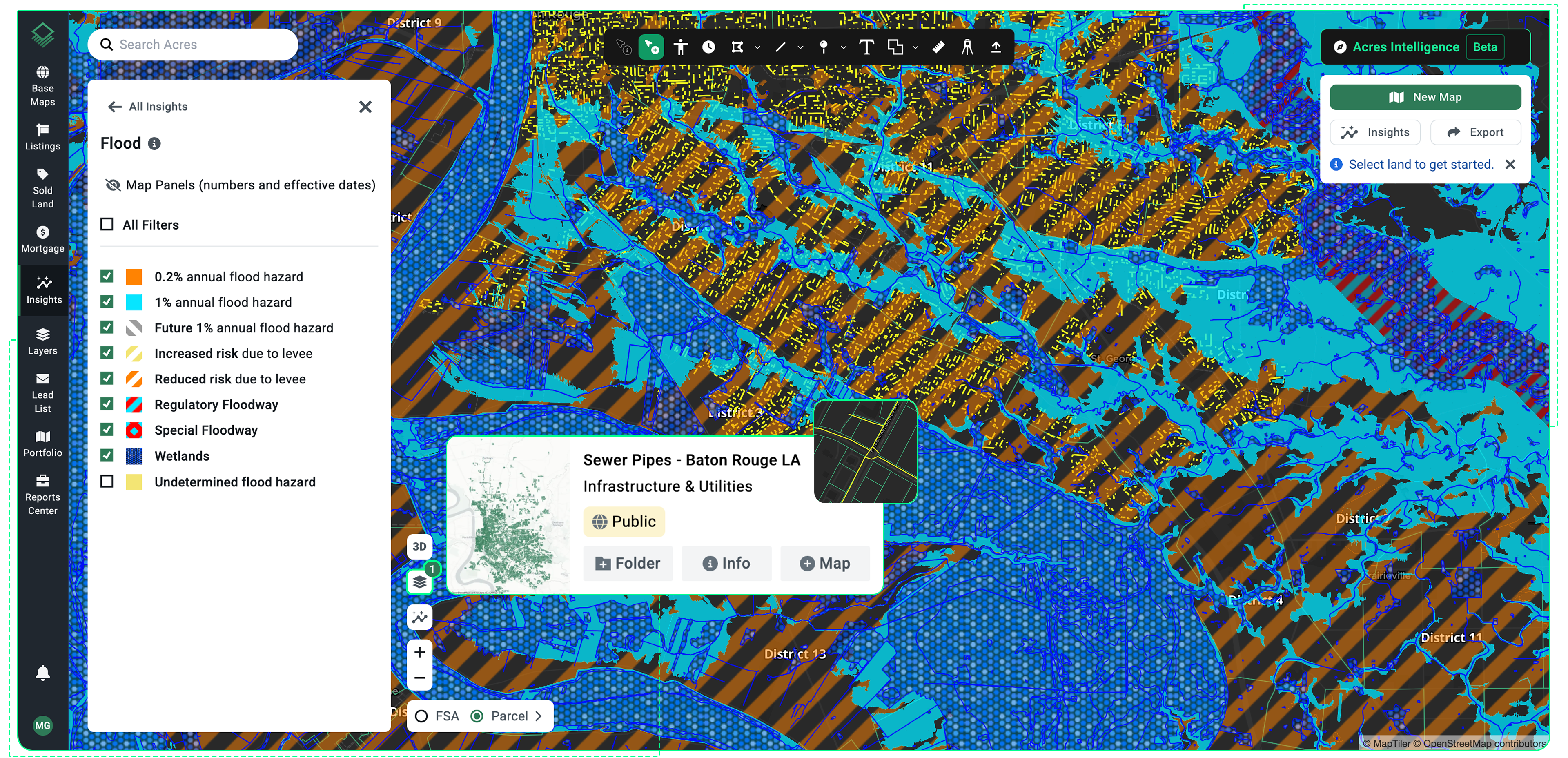
Step 4: Evaluate Zoning, Flood Risk, and Infrastructure Context
A tract's legal boundaries are only part of what determines its value and usability. Zoning regulations vary significantly by county and can restrict residential, agricultural, or commercial development. Flood zone classifications from FEMA can affect financing and insurance costs. Infrastructure proximity, including roads, utilities, and transmission lines, affects development feasibility.
Checking each of these datasets separately adds time and introduces the risk of missing a critical data point. Acres consolidates zoning, flood risk, and infrastructure data into the same parcel view so that due diligence moves faster.
Whether you are working through a single rural tract or evaluating hundreds of land sites across multiple counties, the research workflow is the same: identify parcels, confirm ownership, check overlays, and move to a decision. Acres brings every layer of that workflow into one platform so that weeks of land research become minutes with the most extensive land data available.
How Acres Handles Land Tract Research
Acres Intelligence is built to actively support land tract search, parcel research, and site evaluation with the most extensive, reliable land data available. Rather than describing what you are looking for across multiple databases, you can describe it once inside Acres and get results instantly.
The platform unifies ownership records, parcel boundaries, zoning context, environmental risk signals, and infrastructure data into a single connected view for every parcel.
Land teams use Acres to move from initial tract identification through full due diligence without switching platforms. For anyone evaluating rural land for sale, building a prospecting pipeline, or running a parcel search across a county, Acres surfaces the complete parcel picture so your team can say no faster and say yes with confidence.
Key Takeaways
Land tracts are defined parcels of land with recorded boundaries, legal descriptions, and county ownership data. The terms land plots, land parcels, and land tracts overlap significantly in practice, but all refer to the same core unit of land research. Finding land tracts requires connecting parcel boundary data with ownership records, zoning context, and environmental overlays.
Historically, that meant pulling from multiple disconnected sources. Today, a single land parcel map platform with complete data coverage makes it possible to move from parcel search to due diligence in one place. The most valuable skill in land research is not knowing where every database lives. It is knowing how to evaluate a tract completely and move quickly once you find it.
Ready to run your next land tract search? Connect with our team to start exploring on Acres and see the full picture for every tract you are evaluating.