Development
The Cost of Blind Spots in Land Acquisition and What to Do About It
Uncover the hidden risks in land acquisition and learn how to avoid costly mistakes with Acres.
Learn the essential concepts behind land acquisition, from reading a land acquisition map to understanding land use and land valuation. Know what your land is worth before you buy.

Every year, buyers purchase millions of acres of land across the United States without a clear picture of what they are actually buying. They miss zoning constraints that limit how the land can be used, overlook environmental risks buried in parcel-level data, and miscalculate land value because they are working from incomplete information.
The result is costly delays, deal failures, and land that sits unusable. Land acquisition is not just about finding a parcel and making an offer. It is a research-intensive process that rewards buyers who understand the data before they commit. Acres.com gives buyers the parcel-level data, mapping tools, and land valuation resources they need to move through every stage of acquisition with confidence.
Why Land Acquisition Is More Complex Than Most Buyers Expect
How to Read a Land Acquisition Map
Understanding Land Use and Why It Determines Value
How to Determine Land Value: Key Methods Every Buyer Should Know
How to Find Land Value of a Property
How Acres Supports Every Stage of Land Acquisition
The land acquisition process looks straightforward on the surface: find a parcel, negotiate a price, close the deal. In practice, it is one of the most research-intensive transactions in real estate. Unlike residential properties, land parcels carry a wide range of variables that directly affect usability and value. Zoning regulations dictate what can be built. Environmental conditions determine what risks a buyer inherits. Infrastructure access shapes development feasibility.
U.S. farmland values have climbed steadily in recent years, with the average value of farm real estate reaching $4,170 per acre in 2024, according to USDA. That rise reflects how competitive the land market has become. Buyers who enter that market without a working understanding of land acquisition risk overpaying for parcels with constraints they did not identify, or passing on viable deals because they could not evaluate them quickly.
This guide covers the core concepts every buyer should know before they make an offer.
Land acquisition is the process of identifying, evaluating, and purchasing a parcel of land for a specific purpose. That purpose might be agriculture, residential development, commercial construction, conservation, energy production, or long-term investment. Each use case brings its own set of due diligence requirements, which is why the acquisition process looks different depending on who is buying and why.
At its core, land acquisition involves three stages:
Most buyers who run into problems do so in the evaluation stage, because they do not know what data to look for or where to find it.
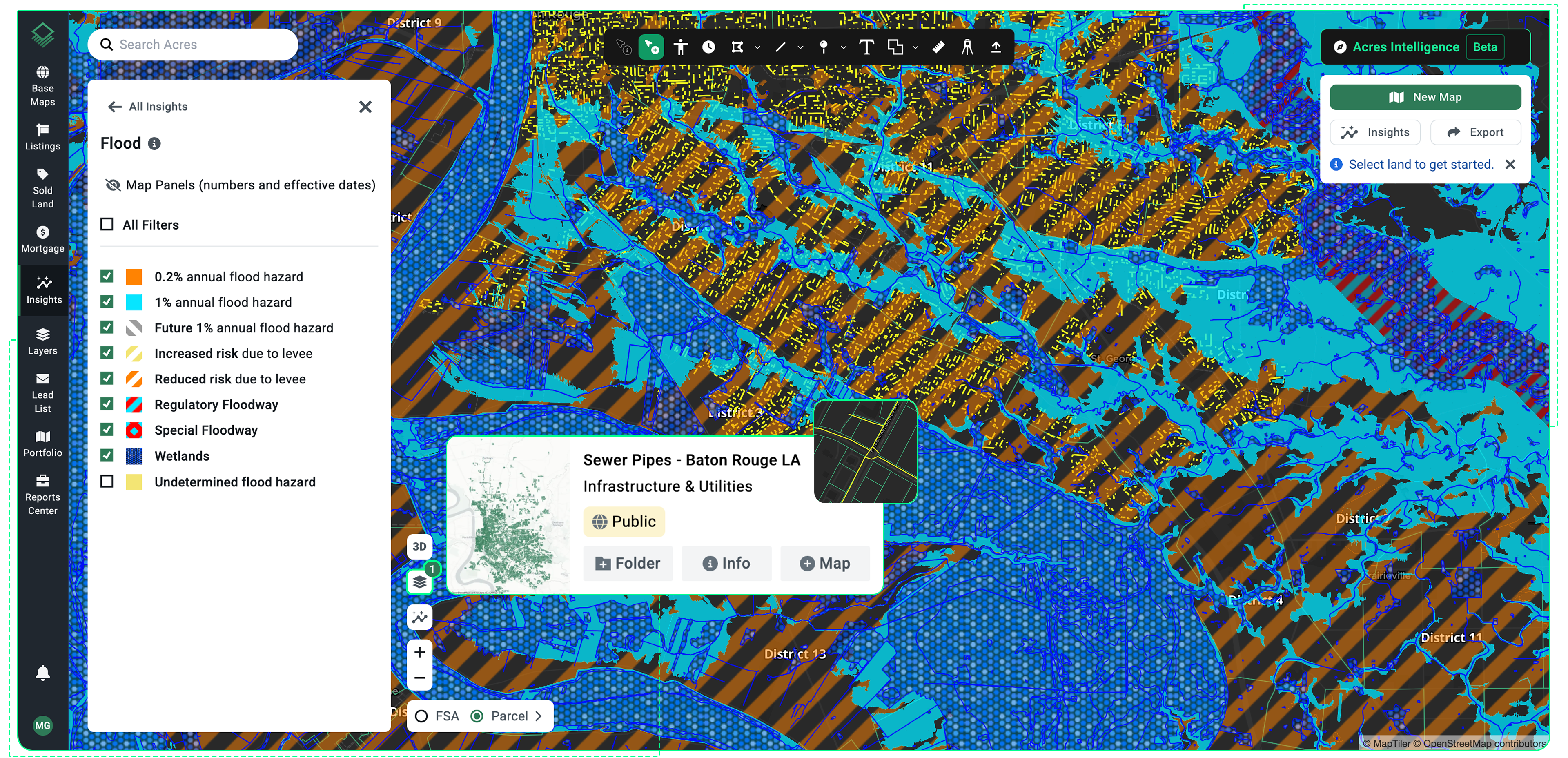
A land acquisition map is one of the most practical tools in a buyer's toolkit. It layers parcel boundaries, ownership data, zoning classifications, environmental overlays, and infrastructure context onto a geographic view of the land. Reading one correctly means understanding what each layer is telling you and how those layers interact.
Parcel boundaries define the legal edges of a property. These boundaries matter because they determine what is included in the sale and whether the parcel connects to road access or utility infrastructure.
Ownership data shows who holds the title and whether there are any liens or encumbrances that could complicate a purchase.
Zoning overlays indicate what uses are permitted on the land under local regulations.
Environmental overlays are particularly important for buyers evaluating land for development. Flood zone designations from FEMA indicate whether a parcel sits in a high-risk area that would require flood insurance or restrict construction. Wetland boundaries show areas that may be protected under federal law
Soil classifications from USDA identify the productivity and composition of the land, which directly affects agricultural and development potential.
Infrastructure context, including proximity to roads, utilities, and transmission lines, shapes the cost and feasibility of development.
A parcel that looks attractive on price alone may carry significant infrastructure costs that only become visible when you map access conditions against development requirements.
With Acres: Acres Intelligence layers ownership records, FEMA flood zone overlays, soil classifications, zoning designations, and infrastructure proximity into a single parcel view. Rather than pulling flood data from one source and zoning from another, you can describe what you are looking for and get results instantly across over 150 million parcels.
Land use is the designation that determines how a parcel can legally be used. It is established by local zoning ordinances and, in some cases, state or federal regulations. For buyers, land use is one of the most consequential data points in the acquisition process because it directly caps what the land can do and, by extension, what it is worth.
Zoning categories vary by jurisdiction, but most systems classify land as residential, commercial, industrial, agricultural, or mixed-use. Within each category, there are typically subcategories that further define permitted density, structure type, and setbacks. A parcel zoned for single-family residential use cannot be converted to a commercial retail site without a rezoning process, which is time-consuming and uncertain.
Land use also affects financing. Lenders assess land value differently depending on permitted use. Agricultural land, recreational land, and commercially zoned parcels each carry different risk profiles in the eyes of a lender, which affects loan-to-value ratios and interest terms. Buyers who understand zoning before they approach a lender are better positioned to structure financing that matches the actual use of the land.
Existing land use is not always the same as permitted land use. A parcel may currently function as pasture while being zoned for light industrial development. Recognizing that gap is part of what makes a sophisticated buyer. The most attractive acquisition opportunities often exist where existing use has not yet caught up with what the zoning permits.
Land valuation is part science, part market knowledge. There is no single formula that applies to every parcel, but there are structured methods that help buyers arrive at a defensible number.
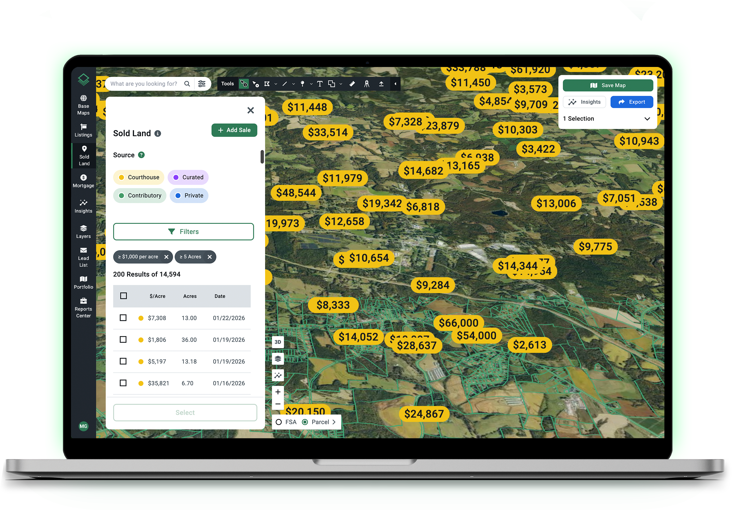
The most widely used method for determining land value is comparing the subject parcel to recent sales of similar land in the same market area. A good comparable, or comp, shares similar acreage, zoning classification, access conditions, soil quality if agricultural, and proximity to infrastructure.
The challenge with comps is finding enough of them. Rural land markets are thin, meaning fewer transactions occur in a given area compared to residential markets. A buyer may need to look across a broader geographic range or across a longer time window to build a credible set of comparables. This is where a land value estimator by address or a land values by zip code tool becomes useful: it helps buyers identify what similar parcels have sold for in the surrounding area without requiring a manual search through county records.
For income-producing land, buyers often apply an income approach: calculating the present value of the income the land is expected to generate over time. For farmland, that income is typically based on cash rent rates per acre. For timberland, the calculation incorporates expected harvest yield and timber prices.
The income approach is most useful when the land has a stable, documented income history. It becomes less reliable for raw land with no established income stream, where the comparable sales approach or a cost-to-develop method is typically more appropriate.
When evaluating land for development, buyers sometimes use a cost approach: estimating what it would cost to bring the land to a developable state and working backward from an assumed end value. This includes land acquisition price, site preparation, permitting, utility connections, and infrastructure costs.
The cost approach is useful for buyers who are making a value-add investment, where the gap between current land value and potential developed value represents the opportunity. It requires accurate data on both development costs and end-use market values, which vary significantly by location and asset type.
Understanding how to find land value means knowing which variables have the greatest impact on price. The Lincoln Institute of Land Policy identifies several factors that consistently drive land value across markets:
Location remains the most significant driver. Parcels closer to population centers, employment hubs, or major transportation corridors command higher values than remote land with similar physical characteristics. This is especially true for land being evaluated for residential or commercial development.
Access and infrastructure directly affect development feasibility and therefore price. A parcel with road frontage, utility connections, and proximity to water and sewer infrastructure is worth more than an otherwise similar parcel that lacks those features. The cost of extending infrastructure to a remote site often exceeds what a buyer expects.
Soil quality and topography matter most for agricultural and rural land. USDA soil surveys classify land by its capability for different uses, from prime farmland to land suitable only for grazing or forestry. Higher-capability soil consistently produces higher per-acre values in agricultural markets.
Environmental constraints, including FEMA flood zone designations and wetland boundaries, reduce usable acreage and limit development options. Buyers should always map environmental conditions against the intended use before settling on a price.
Market conditions and population trends shape demand. The U.S. Census Bureau tracks population growth by county and region, which helps buyers assess whether a market is expanding or contracting. Growing markets sustain higher land values and shorter holding periods.
Finding the land value of a specific property starts with gathering the right data points. Here is a practical sequence:
A land value estimator by address can help buyers build an initial picture of what similar parcels have sold for in a given area. These tools aggregate transaction data and comparable parcel characteristics to generate a valuation range. They work best as a starting point for analysis, not as a substitute for full due diligence on the specific parcel.
Rather than pulling these data points from multiple sources and reconciling them manually, Acres brings ownership records, zoning overlays, environmental data, comparable sales, and infrastructure context into a single platform. Buyers can assess parcel-level detail for any of the over 150 million parcels in the platform without switching tabs or losing time to fragmented research.
Land acquisition demands fast access to accurate, comprehensive data. Acres Intelligence is built to deliver that. With data covering over 150 million parcels nationwide, Acres unifies ownership records, zoning classifications, environmental risk layers, soil data, infrastructure context, and transaction history into a single agent. Buyers can ask in their own words and get results instantly, rather than navigating multiple databases to piece together a complete picture of a parcel.
For teams running acquisition at scale, Acres provides the tools to qualify leads faster, map land values by zip code or county, and identify parcels that match specific criteria before committing resources to site visits. The parcel-level detail available through land valuation tools on Acres helps buyers determine what a parcel is worth before they ever reach the negotiating table.

Successful land acquisition depends on understanding parcel-level data before you make an offer. That means reading a land acquisition map to assess zoning, environmental conditions, and infrastructure access, knowing which land valuation method fits your use case, and identifying the variables that move land value in your target market.
The buyers who move fastest and with the most confidence are those who have already done the data work. They know how to find land value by address, they understand what land use constraints apply to a parcel, and they have a clear picture of comparable transactions in the area. That preparation does not happen by chance. It happens when buyers have the right tools in place before they start searching.
Connect with our team to see how Acres Intelligence can give your team answers in one search. Get the full picture for every parcel, nationwide.

Uncover the hidden risks in land acquisition and learn how to avoid costly mistakes with Acres.
See how the Acres Home Builder Index revolutionizes land acquisition with transparent, accurate, and forward-looking insights for land acquisition...
Learn how non-residential buyers can disrupt land acquisition strategies and how Acres helps builders stay ahead with comprehensive land data.
