“How many lots does this site actually yield?”
For many acquisition teams, getting an answer today means calling in an engineer and waiting one to two weeks for a preliminary layout, time that can lose deals in a competitive market. By the time the numbers come back, the window could’ve moved, or competing buyers snatched the parcel while your capital remained tied up waiting for results.
The fix isn't skipping engineering. It's giving teams a way to pressure-test a site before that call ever gets made. Below is a look at how one homebuilder's acquisition team uses Acres Site Planner to qualify sites in minutes, so the only parcels that reach an engineer are the ones worth the time and capital.
The Problem: Waiting on Engineering or Moving on Instinct
For this team, new site evaluations with a promising parcel, a rough estimate of lots per acre, and a call to the engineer to confirm or disprove that estimate. There was no structured step in between, no way to check a site before committing engineering time to it. Decisions either moved too slowly, waiting on a study, or too fast, running on instinct.
That tradeoff isn't unique to this team. A full lot yield study, sometimes called a feasibility study or build-out analysis, is the formal way engineering firms turn zoning, setbacks, wetlands, floodplain boundaries, and road layout rules into a defensible lot count, a process that takes time and consumes budget. Many teams can't order a full study for each parcel that crosses their desk, so promising sites often get evaluated with less rigor, and some get missed entirely.
The team had tried AI-generated site layout tools to close that gap, with mixed results. Outputs looked reasonable at a glance but fell apart under closer inspection: lots that ignored streams and setbacks, awkward geometry where a road curved unprovoked, cul-de-sacs that weren't buildable as drawn.
Furthermore, the team couldn't steer the layout using their own local expertise or customize the plan to reflect how they actually build—like organizing specific product mixes, optimizing road flow around micro-topography, or thinking through a parcel's unique potential.
That kind of output doesn't just look unpolished, it undermines confidence in the number attached to it. A layout with the wrong lot count isn't useful when that count is what determines whether or not an offer gets made.
The Solution: A Step-by-Step Workflow for Same-Day Lot Yield Feasibility
Today, the builder's acquisition team runs potential parcels through a 5-step workflow inside Acres Site Planner the moment it hits their desk. Here is how the process unfolds and what each phase accomplishes for their bottom line.
The 5-Step Site Planner Workflow
1. Locate and Analyze Parcel → Pull boundary, zoning, and GIS land data.
2. Establish Guardrails and Product Mix → Input environmental buffers and product mixes
3. Interactive Layout Draft → Draw roads, fit lots, 3D grade checks
4. Lot Yield Stress Test → Check density, open space, and acreage counts
5. Report Generation and Handoff → Create branded PDFs for engineers and team members
1. Locate and Analyze the Parcel
The acquisition manager pulls up the boundary for the candidate parcel directly inside Acres. Because the platform aggregates parcel boundaries, zoning classifications, and regional (and national) datasets, the team avoids jumping between multiple county GIS websites or requesting files from municipalities.
How It Helps the Builder: Eliminates administrative friction at the start. The team gets an immediate visual of the property line and surrounding context within minutes.
2. Establish Guardrails and Product Mix
Before drawing a single road or lot line, the team establishes the physical and regulatory constraints of the property. Using Acres’ zoning AI chat, the team confirms local setback rules, density maximums, and land-use designations, then inputs details into the Site Planner.
Simultaneously, Site Planner flags environmental constraints like flood zones and wetlands. The team applies buffers to these features—such as adding a 50-foot buffer around mapped streams or wetlands—so unbuildable land is marked from the start.
Next, they input specific product templates. Whether evaluating a single-family detached community (e.g., 50-foot or 60-foot lot widths) or a townhouse product, they input exact unit dimensions and depth requirements.
Once those templates are set, the team can strategically allocate where each product type belongs on the site map—placing higher-density townhomes near main access points, for instance, while keeping larger single-family lots deeper in the parcel. This is also where the team reserves dedicated acreage for community amenities, stormwater basins, or open space.
How It Helps the Builder: Prevents "false positive" evaluations. By accounting for local code constraints and environmental buffers up front, the team ensures they aren't counting lots on unbuildable acreage. Furthermore, setting up specifications means layouts are tailored to how this builder actually constructs homes.
3. Interactive Layout Generation and Terrain Analysis
With product parameters and environmental constraints locked in, teams can start drawing roads. As the roads are placed, Site Planner automatically populates lots that conform to the defined product dimensions and setback parameters.
During this stage, the team toggles on elevation contours and 3D terrain overlays to evaluate slope and grade. If a proposed road cuts across a severe slope or pushes lots into high-grade areas requiring extensive grading, they can adjust the road alignment on the fly.
The platform also streamlines internal collaboration. Teammates can log into Acres, view the site plan from their own accounts, and tag each other directly on the map to ask questions, leave feedback, or approve layout tweaks in real time.
How It Helps the Builder: Acquisition managers can rapidly test multiple layout configurations (such as comparing a grid pattern to a loop with cul-de-sacs) to find the plan that maximizes lot count while respecting constraints. Seeing terrain impact in 3D reduces the risk of committing to layouts that would lead to extra costs down the line.
4. Lot Yield Stress Testing and Financial Analysis
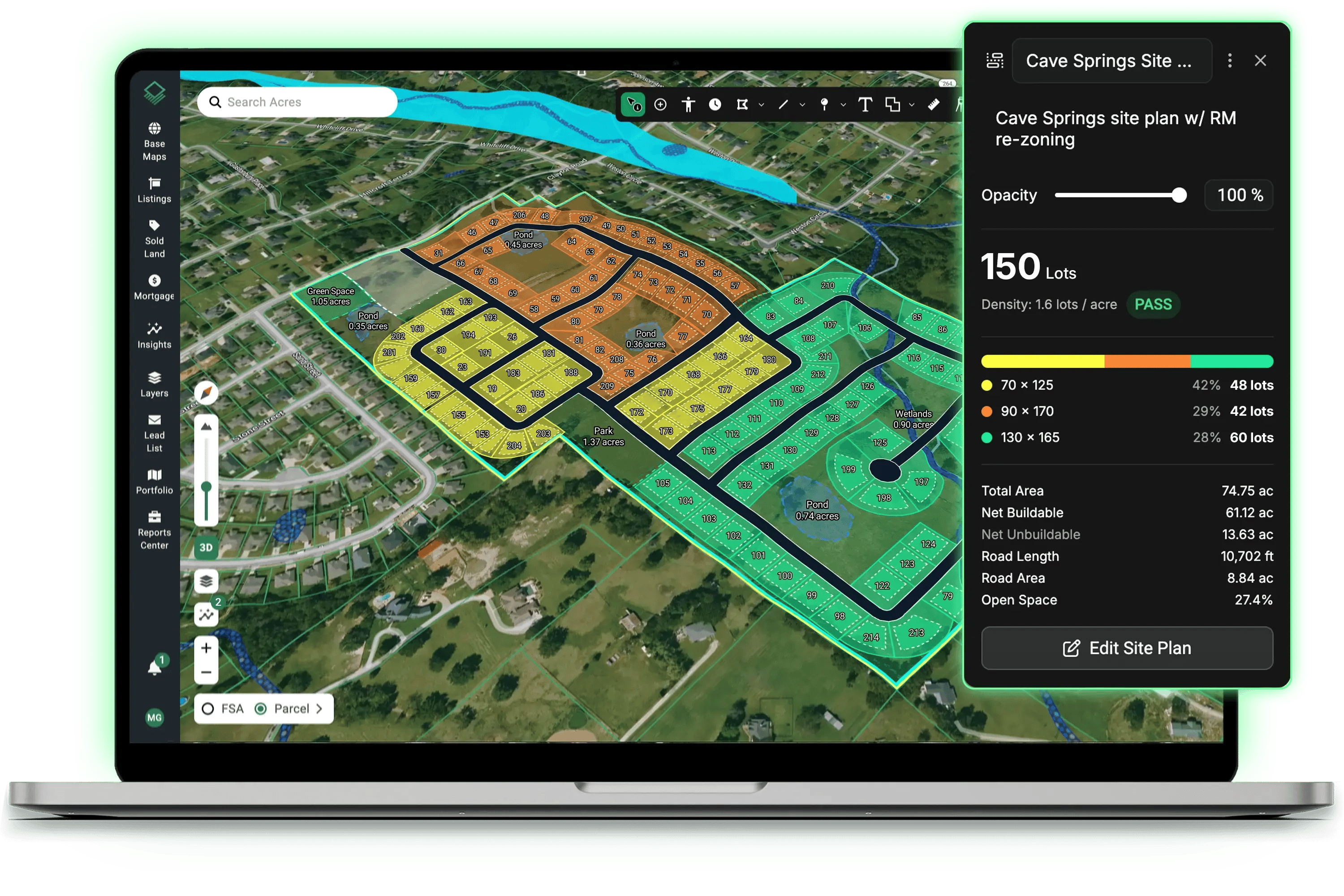
As the layout comes together, the platform’s live lot yield panel provides a complete breakdown of site spatial metrics, including:
- Total Gross Acreage and Net Buildable Acreage
- Total Lot Count and Overall Density (Units/Acre)
- Open Space Percentage
- Total Feet and Acres for Roads
If the initial yield doesn't meet the target numbers to make the financial model work, the team doesn't have to start over from scratch. They can adjust product mix ratios (e.g., swapping 60-foot lots for 50-foot lots), resize specific lots directly on the map, or extend a road to capture unused pocket acreage.
How It Helps the Builder: Delivers immediate clarity for deal underwriting. If a site falls short of required density rules or contains too much unbuildable ground, the builder can pass on the deal immediately. They avoid spending weeks chasing unviable land or wasting thousands of dollars on third-party engineering fees for a deal that was never going to work.
The result is their own plan, designed the way they build and organized the way they think about a site.
Feasibility Decision Matrix
1. Yield Meets Target → Proceed to Underwriting and Engineering
2. Yield Fails Threshold → Kill Deal Before Costs Incur
3. Borderline Yield → Adjust Product Mix / Road Adjustment
5. Engineer-Ready Report Export and Seamless Handoff
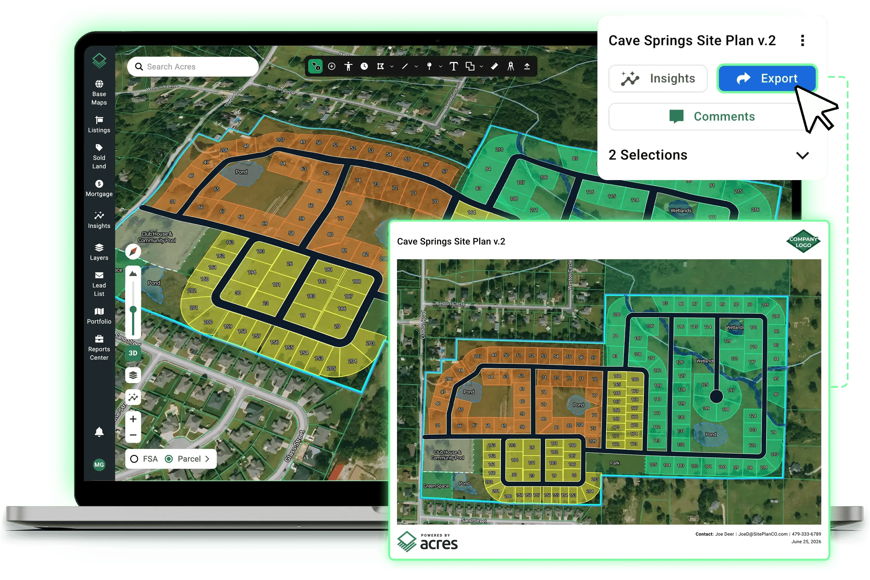
When a parcel clears internal feasibility, the team exports a complete, branded PDF report directly from the platform. This document includes:
- Detailed visual site maps showing lot placement and road networks.
- Maps with identified floodplains, wetlands, and exclusions.
- Statistical breakdowns of net buildable area, density, lot count, and more.
Instead of sending an engineering firm a bare property boundary map and a vague target lot count, the team hands over a comprehensive concept plan backed by data.
How It Helps the Builder: Accelerates the third-party engineering process. Engineers aren't starting from scratch—they are reviewing and refining a plan that already accounts for local zoning rules and environmental constraints and perfectly communicates what your team is hoping to achieve. This can shorten the turnaround time for formal preliminary plans, speeds up pre-application concept meetings with local municipalities, and potentially cut pre-development costs.
Why In-House Lot Yield Feasibility Accelerates Deal Velocity
The team adopted Acres Site Planner for three reasons: the lot count is trustworthy, the layouts are clean and presentable, and the plan works the way they already build.
That reliability transforms the entire pipeline. When a credible yield takes minutes instead of weeks, the team can run more parcels through evaluation in the same period, keep a larger set of opportunities moving at once and reserve engineering budget for the sites that have already earned a second look.
The engineering process still happens, but it no longer has to take weeks. The time savings runs both ways: the development team isn't stuck waiting on a number, and the engineer isn't starting the study from square one.
Want to see how Site Planner could fit into your team's acquisition workflow? Book a demo to get started.
-1.png)